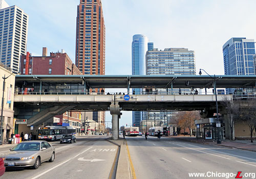
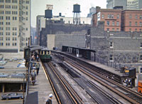
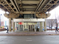
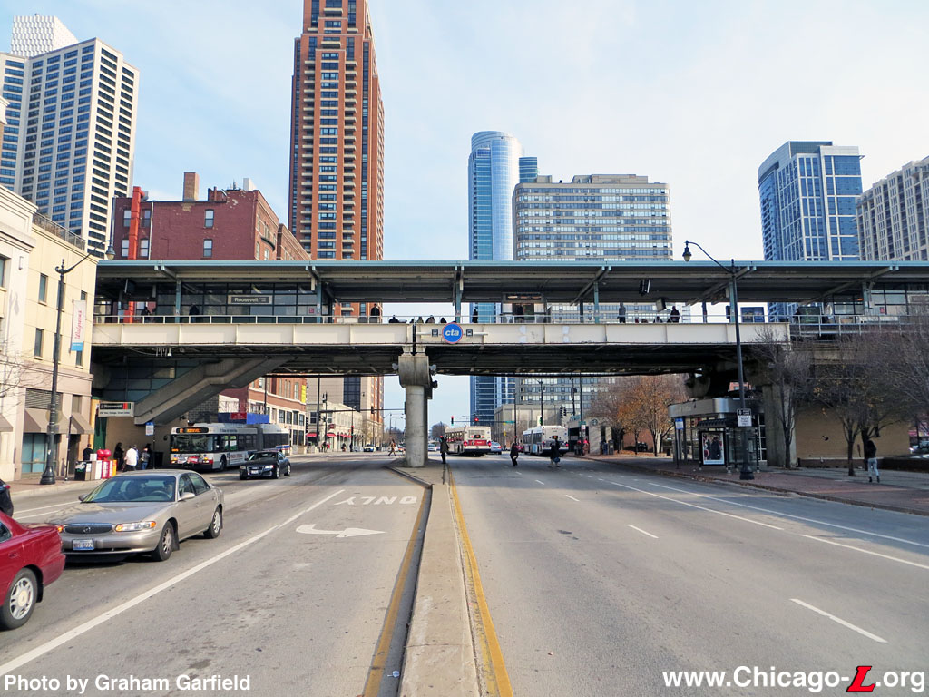
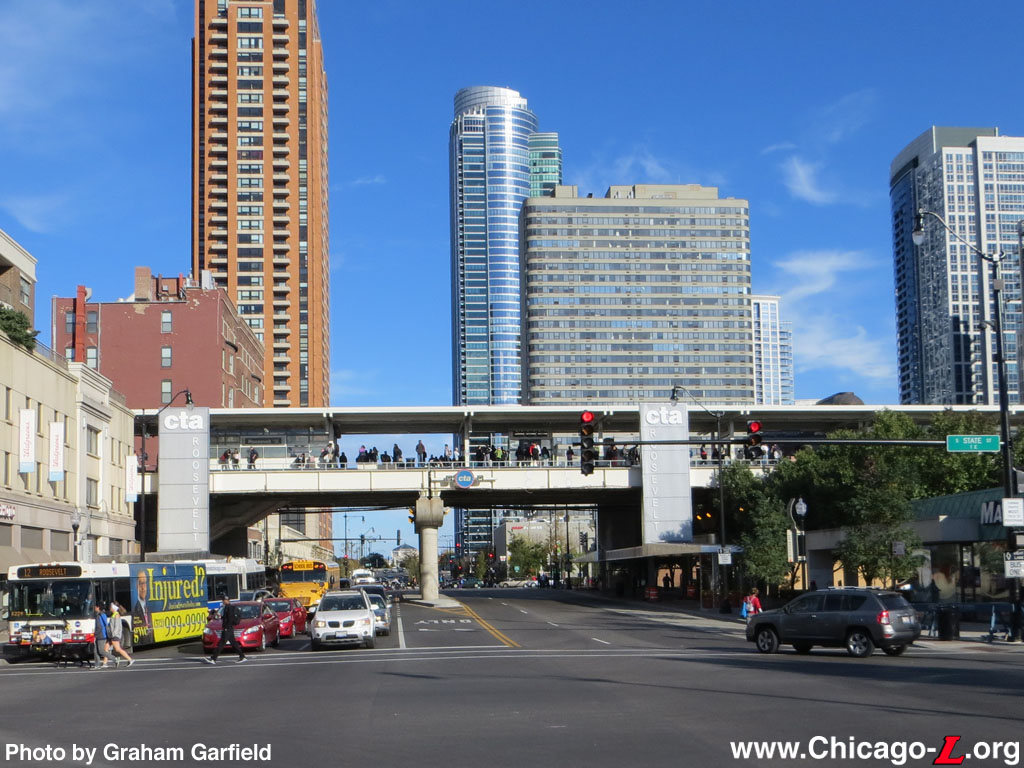
The Roosevelt elevated station is seen looking east on November 22, 2012, with the burgeoning South Loop lakefront neighborhoods visible in the background. The main station house is on the left, with a #12 Roosevelt articulated bus stopping in front, and the auxiliary entrance is on the right. A new viaduct-mounted CTA "identifier" provides clear remote identification of the station, as well as the transit services available there. For a larger view, click here.
(Photo by Graham Garfield)
|
Roosevelt
(1200S/50E)
Roosevelt Road and Wabash
Avenue, Near South Side
Service
Notes:

|
Green Line:
Ashland-East 63rd
|

|
Orange Line:
Midway
|

|
Accessible
Station
|

|
Transfer
Station
|
Quick Facts:
Address: 22 E. Roosevelt
Road
|
Established:
|
June 6, 1892
|
|
July 31, 1949
("L" service
suspended)
|
|
January 21, 1963
(NSL service
suspended, station closed)
|
|
November 1, 1993
(new station
opened)
|
Original Line: South Side Rapid Transit
Previous Names: 12th Street
|
Skip-Stop Type:
|

|
Station
|
Rebuilt: 1993
Status: In Use
History:
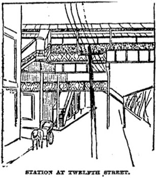
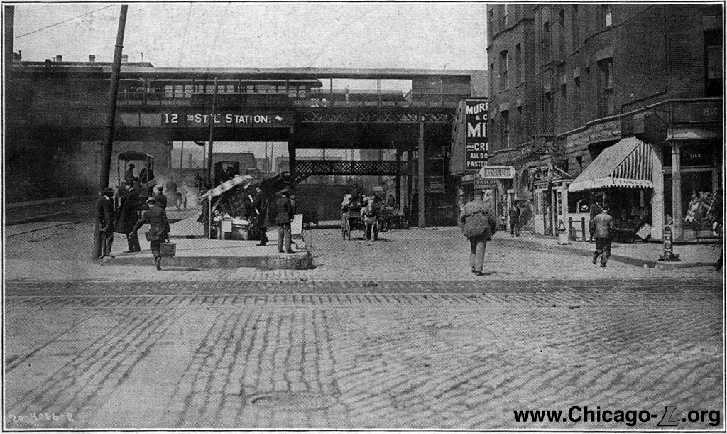
A drawing of the 12th Street station, as seen looking east in 1892. (Image from the Chicago Daily Tribune) |
Roosevelt was one of the original ten stations of Chicago's
first "L" line, the South Side Rapid Transit, between Congress and 39th Street. The Roosevelt station was an unusual one from the beginning, different from the others on the line, due to the particular site conditions were the elevated tracks cross Roosevelt Road, originally called 12th Street.
By the time the South Side elevated was built in the early 1890s, 12th Street had an unusual split configuration between between Wabash Avenue and State Street. The north half of the street, a width of 50 feet, was the original right-of-way and was a level road that connected Wabash and State. The south 50 feet, however, were an incline beginning at Wabash and ascending upward until meeting the elevated 12th Street Viaduct at State Street, jogging north at State to curve over the original street alignment, then bridging over the yard of railroad tracks between State and the Chicago River that approached Dearborn, LaSalle Street, and Grand Central stations to the north. The 12th Street Viaduct incline, while a roadway for public use, was built by and located on private property owned by the Atchinson, Topeka and Santa Fe Railroad. Because the "L" had to span the double-wide roadway that included a ramp ascending upwards, the track structure was built at a higher elevation here to provide sufficient clearance for viaduct incline. In addition, as the tracks crossed 12th Street they curved several feet transitioning between being over the alley-like street Victoria Avenue (later renamed Holden Court) north of 12th to being on private property south of 12th.
As a result of all of these site conditions, the 12th Street station seems to have differed in its design from the other stations on the original stretch of the South Side elevated. Unlike the street-level masonry station houses built at 18th Street and points south, the 12th Street station appears to have been built with a mezzanine station house on the north side of 12th Street. How much of the mezzanine was over private property on the northeast corner of 12th and Victoria and how much was over Victoria is unclear. Stairs from the north side of 12th Street led up to the mezzanine station facility. In addition, there was a pedestrian bridge over the north half of 12th Street, under the "L" structure, that led from the 12th Street Viaduct incline directly into the station mezzanine. The station's side platforms curved with the tracks at their north ends, where the stairs from the mezzanine station facility connected. The platforms appear to have had the "humpbacked" canopies characteristic of the original South Side Elevated stations, though 12th Street's appear to have been longer than most, spanning the width of the double-wide street.
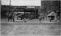
A view of 12th Street looking west from Wabash circa 1900, and the "L" station overhead. The street on the right continues at ground level to State Street; the street on the left ascends up to the 12th Street Viaduct. While the "L" platforms span over the street, the entrance to the station is on the north side of the ground-level roadway, on the right. Note the pedestrian bridge from the station over the ground-level roadway to the viaduct ramp, so that pedestrians from the viaduct have a direct path to the station rather than having to go down to Wabash then double back.
For a larger view, click here. |
In March 1907, the South Side Elevated completed work on the installation of a third track between 12th Street and 43rd
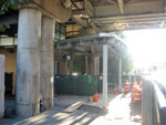
Street to allow express service to be operated in the peak direction of travel during rush hours. For most of the distance the third track was added, the additional structure and track were built on the east side of the existing elevated structure, with the new track becoming the new northbound local track and the old northbound track becoming a bi-directional express track. This required the relocation of the northbound platforms at the stations between 18th and 39th streets, inclusive. However, from north of about 14th Street to just north of 12th Street, where the new three-track alignment ended and went back to two tracks for the remaining distance to the Loop, the third track was added on the west side of the structure. Because the original two-track alignment curved southeast as it extended southward over 12th Street, the addition of the third track on the west side of the structure essentially allowed the southbound track to be extended in a straight alignment as it transitioned from the old alignment to the new track. The old southbound track became the center track, and terminated near the north end of the station. An interlocking with switches between each of the outside local tracks and the center track was installed just south of the station, controlled by a tower at the south end of the new southbound platform. Express trains began and ended their express runs here, south of 12th Street. The center track north of the interlocking was a spur for turning trains or storing cars, and had a capacity of five cars.
In addition to relocating the 12th Street station's southbound platform to the west on the new southbound track, the platform was also moved or extended south, so that the two side platforms became staggered. The new southbound platform extended about 270 feet farther south than the northbound platform. As part of the same city ordinance that permitted the addition of the third track, the South Side Elevated was required to pave the land under its tracks and provide sufficient clearance to allow traffic to pass underneath the stations. At most stations, this required the demolition of the original ground-level station houses and the raising of the elevated structure to provide sufficient clearance between the ground and the new mezzanine station houses (with grades of up to 1.44% at some stations
to compensate for the change in elevation). However, because the elevated structure was already at a higher elevated at 12th Street due to the 12th Street Viaduct incline under the structure, and the 12th Street station already being a mezzanine, 12th Street station was one of the only places where these changes were not required as part of the project.
Beginning in 1919, trains of the Chicago North Shore &
Milwaukee interurban entered Chicago via trackage rights on the Evanston and North Side "L" lines and the Loop, terminating at Roosevelt Road from 1919 to 1922. From 1922 to 1938, North Shore Line train service was extended south to Dorchester, but resumed terminating at Roosevelt again from 1938 until the end of service in 1963.
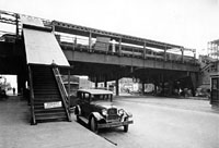
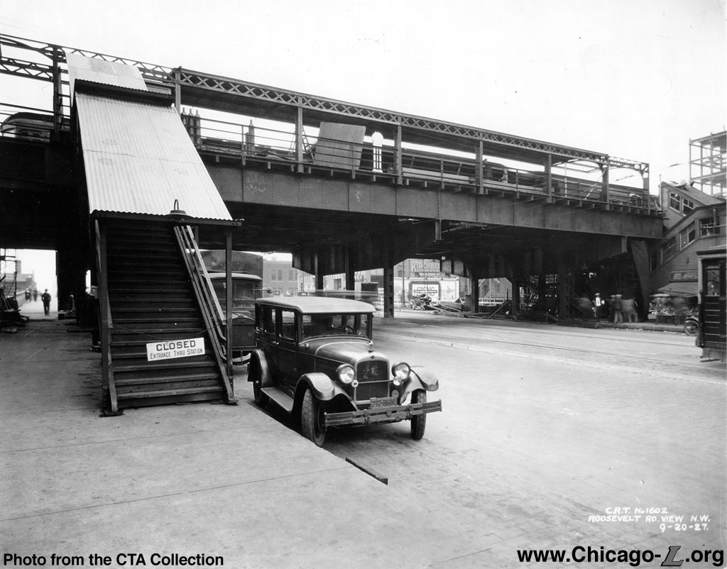
The rebuilt Roosevelt Road station is seen looking northwest on September 20, 1927. The canopy on the inbound platform seen above is still being completed. Enclosed stairs from the station entrance to the platform are visible on the far right; the stairs in the left foreground appear to be auxiliary exit stairs, as-yet unopened.
For a larger view, click here. (Photo from the CTA Collection) |
In the mid-1920s, the station (by then, like the street, renamed Roosevelt Road) was modified and the elevated structure altered to accommodate the widening of Roosevelt Road. The street wasn't so much widened -- the total right-of-way of the original road and the old viaduct incline already had a total width of 100 feet -- as the two halves joined together. The old arrangement was changed to create one 100-plus foot-wide street that ramped up from Wabash to a new viaduct over State Street and the railroad yards. The associated work on the "L" was estimated in Spring 1923 to cost of $161,000. This work extended until at least late 1927, when work was still being performed on the platform canopies and the station entrance on the north side of Roosevelt Road.
The project rebuilt the elevated structure spanning Roosevelt Road, which originally had a more typical structure design over the north half of the street and a steel span bridge over the viaduct incline. The project provided a long steel span over the new, combined, wider Roosevelt Road with new column supports at the curbline and in the middle of the roadway. The project also rebuilt the canopies over each platform, replacing them with new canopies with curved support columns along the railings supporting a cantilevered gently arched roof with latticed framing along the top of the canopies' back side -- this type of canopy was first used in 1907 on the Ravenswood
branch stations before becoming the standard for the "L" under the
Chicago Elevated Railroads and Chicago Rapid Transit. Auxiliary exit stairs descended from each platforms to the south side of Roosevelt Road, though it is unclear if these existed before the project or were added as part of it; they were also removed at some later point, as they were gone by the 1960s and perhaps earlier.
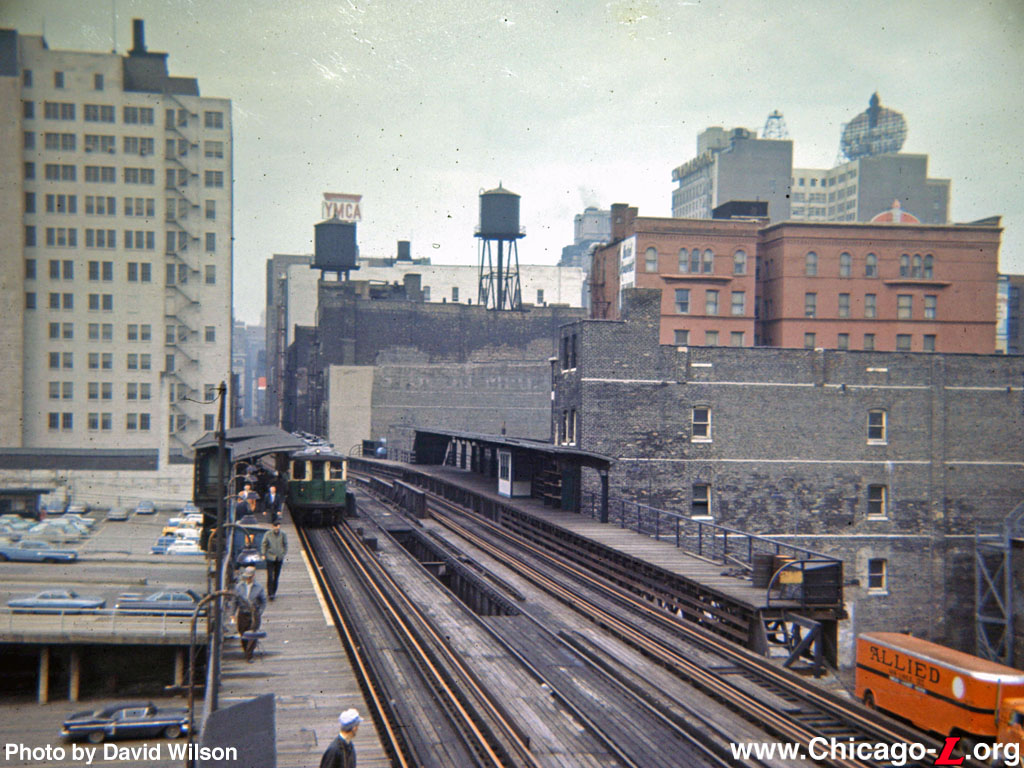
The Roosevelt Road platforms are seen looking north on May 15, 1966. Although there are 4000-series "L" cars in the view, it is a fantrip and the station had been closed for several years by this point. Note the pit in the center track, used for inspecting and servicing North Shore interurban cars.
For a larger view, click here. (Photo by David Wilson) |
By the mid-1940s -- but most likely built in the renovation of the station in the mid-1920s -- the main entrance to Roosevelt station on the north side of the street was a large facility open to the street. Rather than an enclosed station house, the entrance was a street-level facility under the tracks with side and rear walls but no front facade, instead opening directly onto the sidewalk. The entrance was covered by a wide arched roof with rows of incandescent lights under porcelain-enameled shades, like those commonly used on the platforms and inside many station houses. The facility had two, large, double-wide ticket agent booths to handle the large amount of passenger traffic the station saw, which included North Shore Line interurban passengers. The stairs to the platforms ascended from the rear of the facility. With its substantial size and "plaza-like" design open to the street, the Roosevelt station facility was conceptually similar and in some ways a precursor to the fare control facilities built at Belmont and Fullerton in 2006-09.
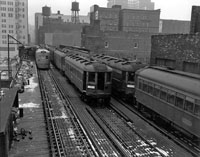
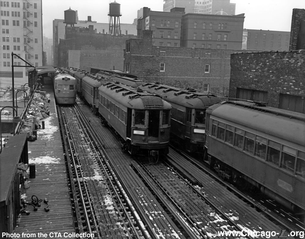
Several North Shore Line interurban trains are at Roosevelt Road on January 12, 1963, including one of the famed Electroliners on the left. The train in the middle is laid up for temporary storage. Roosevelt Road was the south terminal for North Shore service at the time. A little more than a week later, the interurban would abandon service.
For a larger view, click here. (Photo from the CTA Collection) |
On August 1, 1949, the CTA instituted its North-South Route service revision, which consisted of the streamlining of service patterns, institution of A/B
skip stop service, and the closure of low-ridership stations. As part of the service
revision, "L" service on the South Side Main Line from Wabash/Van Buren (Tower
12) to 15th and State streets was discontinued after all service to and from the South Side was routed into the State
Street Subway as part of the new North-South Route. Roosevelt station was one of 23 Howard, Jackson Park-Englewood and Ravenswood stations
with "L" service discontinued (including 18th, 26th, 29th, 31st, 33rd, and 39th on the South Side Elevated), but unlike the other stations, which closed completely, Roosevelt was still used for North Shore Line
interurban trains. Although it was then a station serving only interurban trains and passengers, the station continued to be staffed with CTA station department personnel. The interurban continued to terminate its trains at the Roosevelt Road station. The middle track through the station, originally for express trains, was especially useful for shunting equipment and storing cars midday and off-peak. For trains that had baggage or parcel service, normal
procedure was for a combine to be held open at Congress
Terminal to receive baggage and merchandise dispatch shipments
until about 15 minutes before a scheduled northbound departure from
Roosevelt Road, then run half a mile south to Roosevelt to couple
onto the coaches.
After the North Shore Line ceased operation on
January 21, 1963, the station closed and was eventually demolished, although it lasted as least as late as 1966. The elevated tracks through the former station site, between Tower
12 and 15th Street, however, were never torn down and were maintained as a non-revenue connection between the Loop and South Side Elevated. The alignment was put
back into regular "L" service only a few years later in 1969 when the newly opened Dan Ryan Line was
routed onto the Loop via these tracks and a new connection at 17th
Street. Still, due to its close proximity to the Roosevelt
station in the State
Street Subway about 1/2 block to the west, no station was
rebuilt at Roosevelt Road on the newly reactivated line.
Station Returns with the Orange Line
Following decades of planning, work began on the new Southwest Transit Project (SWTP) in 1987, connecting the Southwest Side, the only
part of the city then without an "L" line, with downtown. The line
was built relatively inexpensively (about $500 million) using old
abandoned railroad rights-of-ways, including those previously used by
the Illinois Central Railroad, Santa Fe Railway and the Belt Railway
of Chicago. The new line connected to the old South Side Elevated at
17th Street, then used the existing elevated line to access the Loop.
A new Roosevelt station was built on the South Side Elevated as part
of the Southwest Rapid Transit project and ground was broken for the
station in 1990. The Southwest Route entered service as the Orange
Line, following the CTA's then-newly adopted color-naming convention, on October 31, 1993.
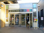
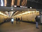
The Roosevelt station house is seen looking northwest on November 26, 2002. Station amenities inside
include a concession, waiting areas in the unpaid and paid areas, and ticket vending machines. Decorative benches adorn the interior.
For a larger view, click here. (Photo by Graham Garfield) |
One of eight stations built for the line, Roosevelt is typical of
the facilities designed and built for the Southwest Transit
Project. The stations, designed in the late 1980s and early 1990s, are
typical of urban design in general and transit planning in particular
during that period. The general design of the station is typical of
the other Orange
Line stations, although there are a few differences
at Roosevelt. Although there are rail-bus transfers available at the
station, due to its more constrained site and denser urban setting
the station house is situated at the sidewalk and there is no
off-street bus terminal. There is also no park'n'ride lot.
Design of the station facility was overseen by the City, who
encouraged the architects to use distinctive styles for the stations
while conforming to a basic uniform layout and footprint. The station
house, located on the north side of Roosevelt Road, has a short
facade of glass windows framed by steel panels and light green steel
mullions facing the street, immediately east of the elevated
structure. The part of the station house's south elevation that is under the elevated structure is
merely a blank tan brick wall. The headhouse, whose long elevation
runs parallel to the tracks, is topped by a thin light green-painted
steel cornice.
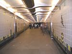
The interior of the
Roosevelt station house, looking north in the unpaid
area on November 26, 2002. The glass walls give the station
a lot of natural light, while the numerous turnstiles allow for easy handling of large passenger flows.
For a larger view, click here. (Photo by Graham
Garfield) |
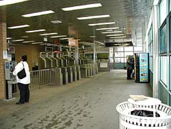
The interior of the station house is simple and typical of all
Orange
Line stations. The floors are concrete and the ceilings are
made up of metal strip panels. The walls that do not have large
picture windows are clad with the same tan brick used on the solid
walls on the station exterior, punctuated by light green steel doors
and moldings. Finishes in the building, such as the grilles, sign
boxes, and the agent's booth, are stainless steel and tend to
be rectilinear in design. The original turnstiles, replaced in 1997 with
Automatic Fare
Collection (AFC) Cubic-made TransitCard turnstiles, were also very rectilinear.
The booths are significant in that they were the first specifically
designed not to primarily function as fare collection facilities.
Although there were still ticket agents at the time (called "Transit
Assistants" on the Orange
Line) and Customer Assistants as we know
them today would not exist for another four years after the station
opened, the Orange
Line was the first to prepare for the time when
fare collection would be more automated. The agent in the booth did
not collect fares, though they did verify reduced fare eligibility
and accept transfers, and functioned more as an information
assistant. Fares were to be paid at the turnstiles, and individuals
that did not have exact change could use one of the Orange
Line's specially-installed token vending machines. Following the
installation of the AFC equipment, these machines were removed and
standard TransitCard Vending Machines (TCVMs) were installed. The
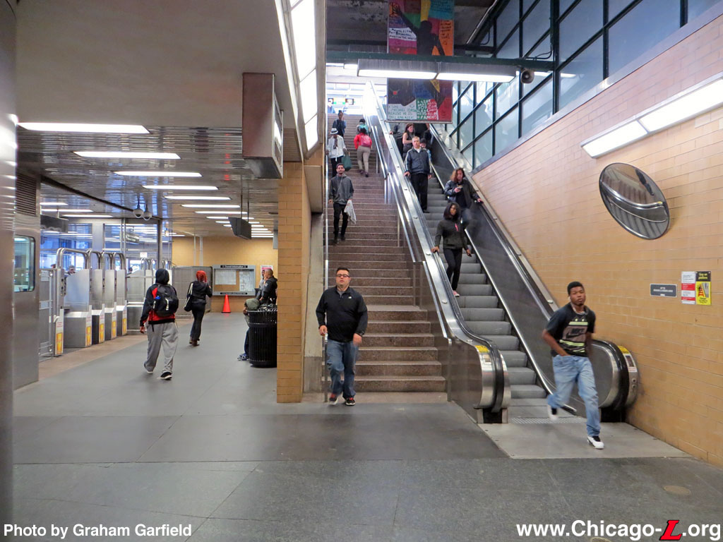
station also has a concession space. Two stairs/escalators sets lead to the elevated platform, as well as an elevator,
making the station ADA compliant and accessible. The interior was
subsequently outfitted with decorative painted benches and
murals after opening.
The platform is of the island variety, with a concrete deck and a
full-length canopy. The canopy has a flat roof, unlike the gable
roofs at most Orange
Line stations, and is supported by two rows of
square steel columns. The canopy, whose columns and fascia were
painted light green and underside was painted white, extends out to
the centerline of each track. The platform is outfitted with flat
concrete slab benches and H-plan glass and steel windbreaks, with a panel on top that holds a station name
sign inside a frame. Behind each stairway is another windbreak
waiting area.
An auxiliary rotogate exit was included as part of the station on the south side of
Roosevelt Road, allowing passengers to transfer from the "L" to
eastbound buses without crossing the wide, busy the street.
The new station, the first on the site in over 40 years, serves
both Green (Lake-Jackson Park-Englewood) and Orange (Midway) line
trains. It also serves as the station for the Museum Campus,
about five blocks east on the lakefront, and the burgeoning South Loop neighborhoods.
Roosevelt Transfer Tunnel
Following the closure of the old Chicago Police Headquarters on
State and 11th Streets, Mayor Richard M. Daley introduced a plan to the City Council to demolish and replace the facility with a new mixed-use development with
residential, retail and parking components. As part of the project,
the developers worked with the
CTA to build an underground
connection on the southern end of the site from the Roosevelt/State Red Line subway station to the
elevated Orange and Green lines Roosevelt/Wabash station. The city originally intended to build a pedestrian tunnel at Roosevelt when the Orange Line was completed in 1993, according to former deputy Chicago transportation commissioner Stan Kaderbek, but the project was not undertaken due to cost
constraints. "It was a money issue back then," said Kaderbek in 2002.
The Roosevelt Transfer Tunnel -- also formally known as the Near South
Intermodal Transfer Tunnel -- was designed by Muller & Muller
Architects for the Chicago Department of Transportation (CDOT). The
budgeted cost for the project was $7.5 million, though the final cost
is said to have been closer to $10 million. Funding was provided
through Illinois FIRST and a federal Congestion Mitigation and Air
Quality (CMAQ) grant. Work on the project began in November 2001.
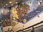
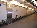
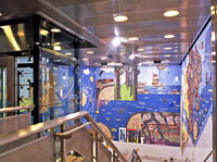
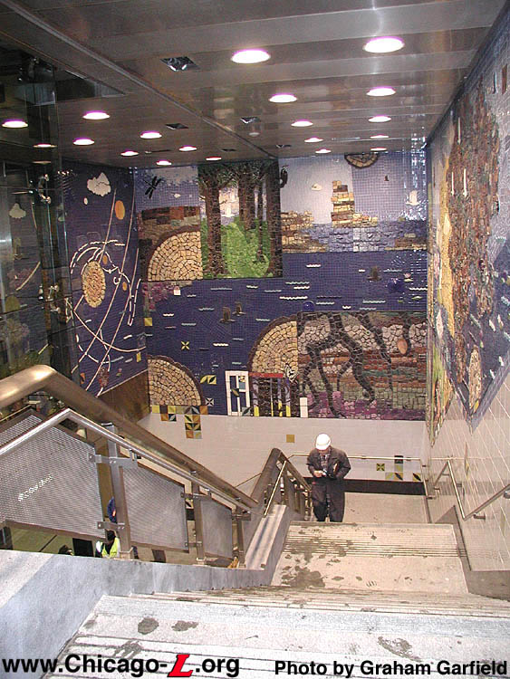
At the east end of the
tunnel is a large mural, titled "Hopes and Dreams," composed
of more than 4,000 colorful tiles created by visitors to the
Museum Campus in 1999. This view looks northeast from the
Green / Orange Line station level on November 26, 2002. For
a larger view, click here.
(Photo by Graham Garfield)
|
The aesthetic concept for the tunnel is a historical timeline of the Earth centering around the disciplines of the three museums represented on the Museum Campus:
the Field Museum of Natural History, the Shedd Aquarium, and the
Adler Planetarium. Additionally, there is dedicated space for the
City of Chicago Arts in Transit Program. At the east end where the
vertical access between the tunnel and the Green/Orange Line station
house is located, the tunnel is adorned with a large mural composed
of more than 4,000 colorful tiles created by visitors to the Museum
Campus in 1999. The mural, titled "Hopes and Dreams," was created by
Juan Angel Chavez and Corinne D. Peterson of the Chicago Public Art
Group. In recognition of the Museum Campus and its three
institutions, it depicts clouds, forests, oceans, earth and space,
representing the Field Museum, Shedd Aquarium, and Adler Planetarium,
respectively.
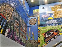
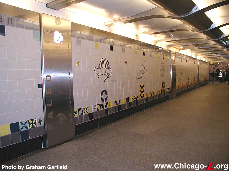
The walls of the tunnel itself displays a timeline of history,
from the Big Bang to human space travel, with graphics glazed into the
tiles showing various plants, animals, and celestial bodies. These
are broken up by stainless steel pilasters that have a cutout backlit
shape at the top (again, a plant, animal, or celestial body). These
mark the changeover between eras (i.e. Paleozoic Era, etc.), with text engraved on the piers explaining the benchmarks in the history of
Earth and the universe.
The tunnel also features a granite floor and a stainless
steel ribbed ceiling that almost resembles a mammal's ribcage and
spine. In addition, the elevator serving the tunnel features
a stainless steel frame and point-supported glass cladding, meaning
the glass members are attached to the steel elevator tower by means of
pins at each corner. Thus, you can see through the elevator, and for
security purposes, the CTA can
see through its hoistway. So it results in both an elegant look and
provides security as well. There is also soft music piped into the tunnel,
creating a complete ambient experience. The instrumental music was chosen by CDOT and consists of 12 individual tracks that continuously play on a
30-minute loop.
As part of the project, the Roosevelt/Wabash station was expanded
northward somewhat. The tunnel connects to the Roosevelt elevated
station by way of an elevator, escalator and stairs to the northwest
corner of the grade-level station house, in the paid area. To make the connection, the north wall on either side of the elevator to the elevated platform was removed and a short extension added to the rear of the building to provide a corridor between the station house and the vertical access to the tunnel. The tunnel
emerges in the Roosevelt subway
station on the east side of the mezzanine in the paid area, between
the fare controls and the stairs down to the platform.
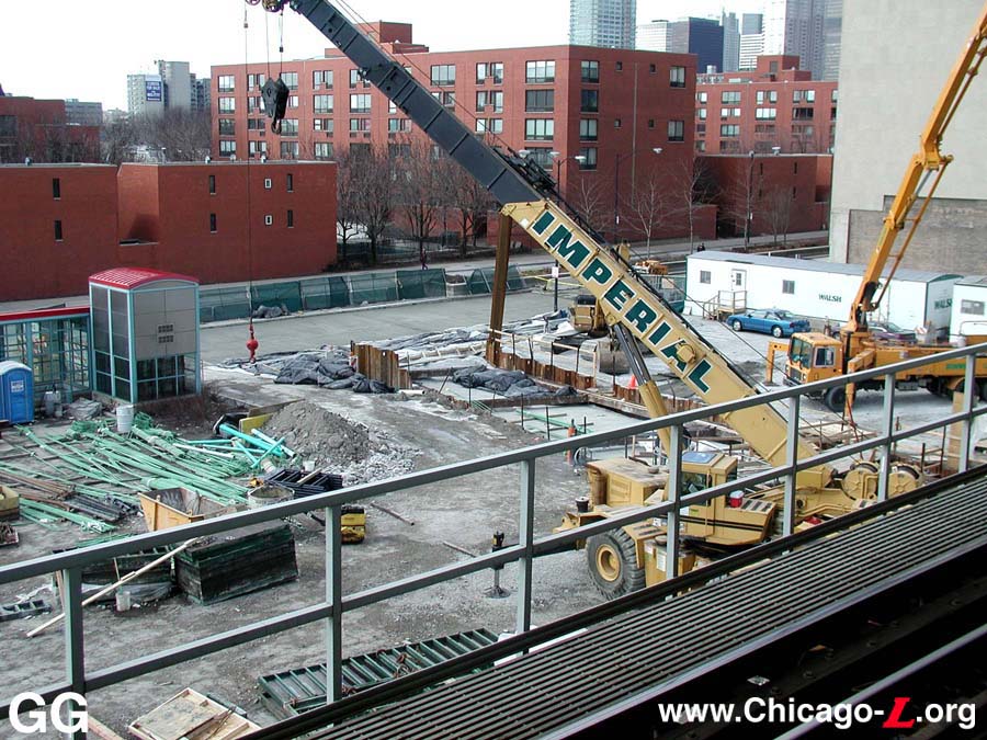
The tunnel itself was excavated, dug in the cut-and-cover method,
and was covered over with concrete decking. One of the construction
team's first challenges was the tunneling. Since it's near the lake,
there is a high water table, and the clay earth there is saturated,
making it very, very wet. To take care of that, a "mud mat" -- a thin
layer of concrete -- was poured. Once it was excavated to the proper
depth and the mud mat was put down, a stable base was provided to
work off. Actually excavating the tunnel was fairly simple because
the structure was to be dug and constructed primarily under an empty
lot. Sheeting was driven from the ground down on either side of the
tunnel's footprint and extended far below the bottom of the
excavation. Once the sheeting was in place, the general contractor,
Chicago-based Walsh Construction Co., excavated the earth between the
two parallel sheetings.
Effective at 10am, Monday, April 22, 2002, the elevator at
Roosevelt/Wabash between the station house and the elevated
platform was taken out of service for approximately two months. The elevator was refurbished and the
machine room relocated to accommodate the construction of a new
tunnel connecting Roosevelt subway
and elevated stations.
The Roosevelt Transfer Tunnel opened on Saturday, December 7,
2002.
Recent Developments
Roosevelt station received some signage upgrades in the mid-2000s. In
2004, the column signs were replaced with new ones with a Green Line
Graphic Standard design similar to those they replaced (the
original Modified
KDR Standard column signs had been replaced years before). The
overhead backlit directional signs on the platform were also replaced
at that time, changing the verbose directions on the old sign faces
to simpler roller curtain graphics. In late Spring 2005, the station
name signs on the platform were replaced as well, with Green Line
Graphic Standard signs replacing the Modified
KDR Standard originals.
Although the companies the
CTA has contracted with over
the years to handle their station and railcar advertising -- Obie,
Viacom, CBS
Outdoor Advertising, and most recently Titan Outdoor -- have long had the right to install
advertising frames and ads at Orange Line stations, this right was
not exercised for over a decade, leaving the Orange Line stations
ad-free, somewhat of an anomaly on the "L" system. CBS Outdoor
finally fulfilled this contract option in June 2006, installing
freestanding advertising panels at all Orange Line station platforms
except Midway (where there is insufficient
room). The panels are lined up along the centerline of the platform,
between the already-present benches, trashcans, windbreaks,
elevators, and stair/escalator enclosures.
South Auxiliary Entrance
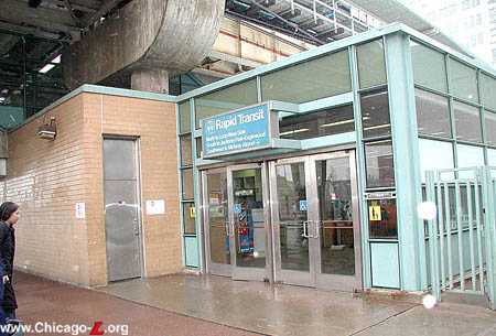
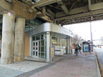
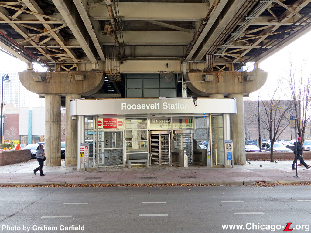
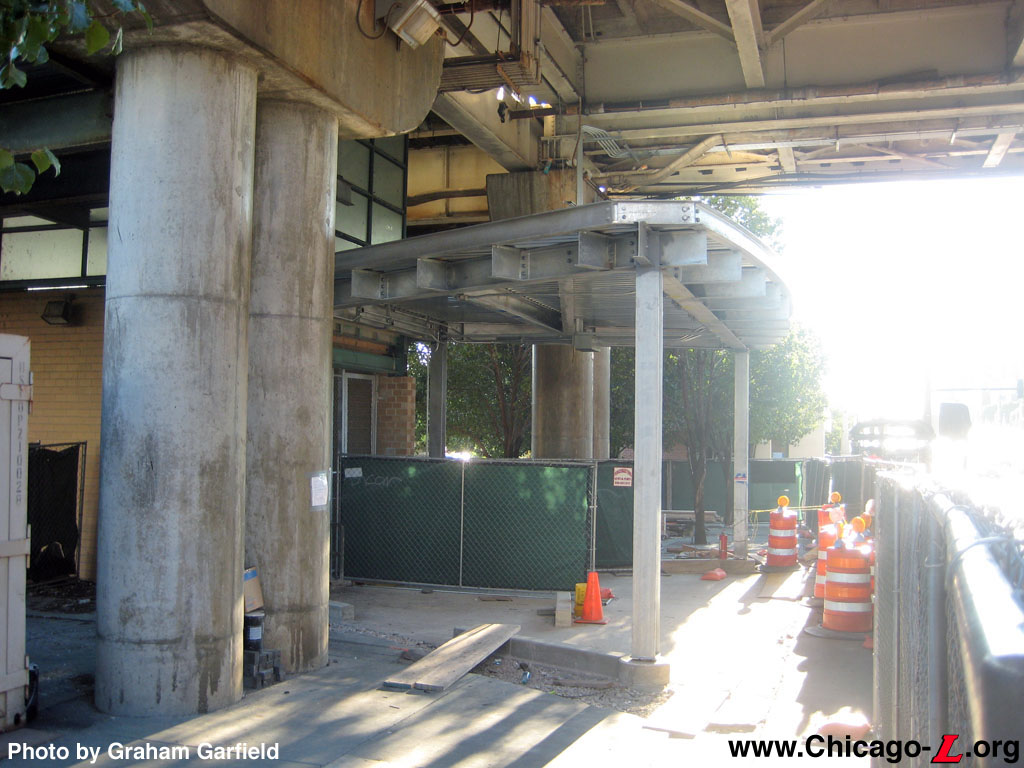
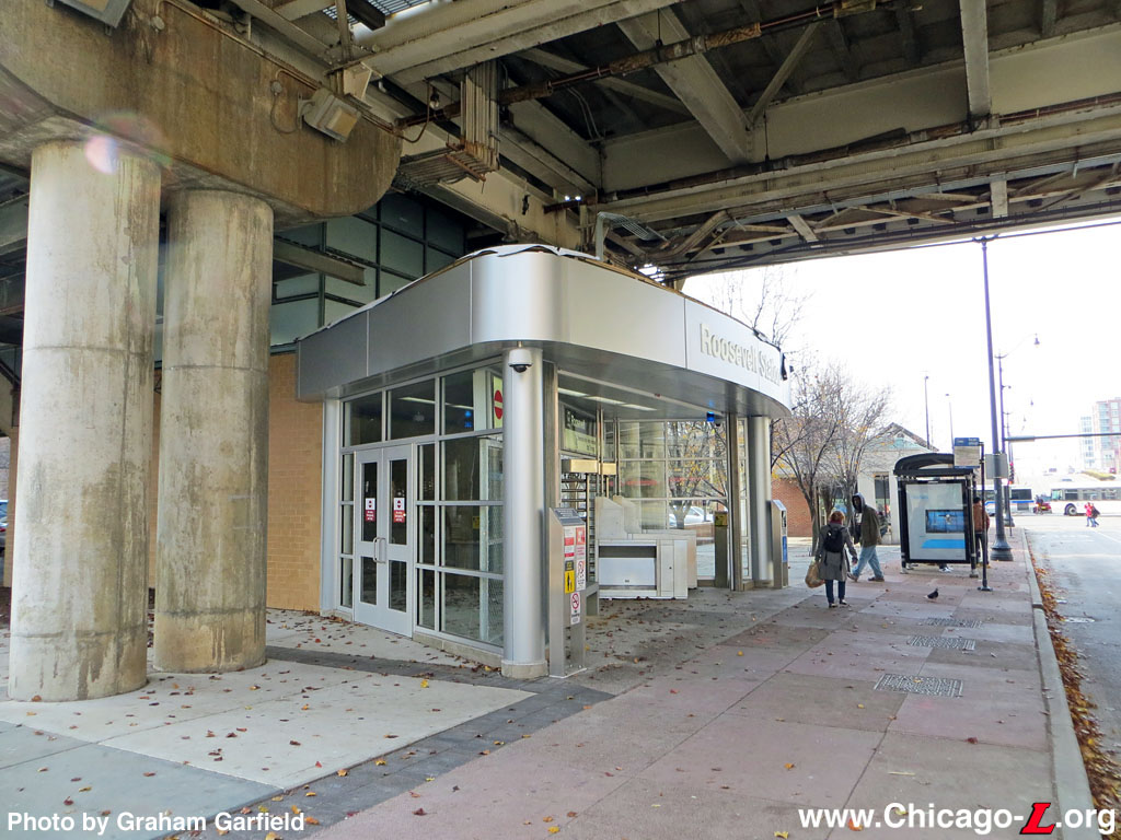
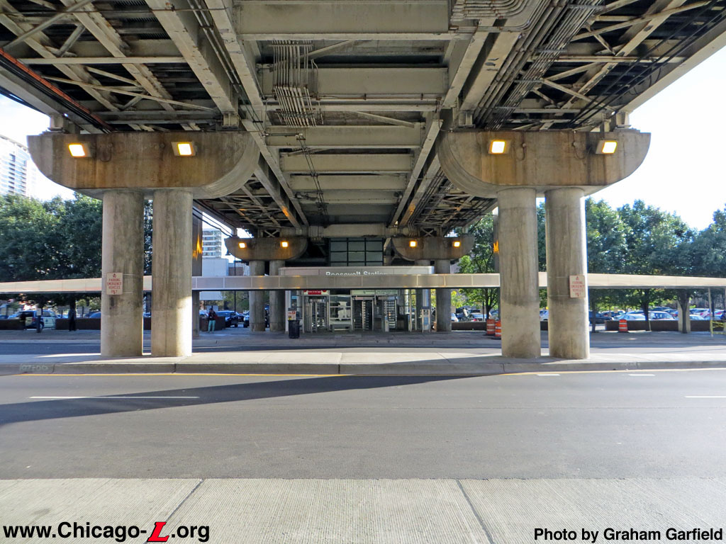
In 2012, the CTA renovated the auxiliary exit at the Roosevelt Orange/Green lines station to provide a more convenient transfer between buses and elevated trains, and some additional improvements for the station as a whole.
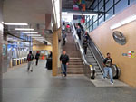
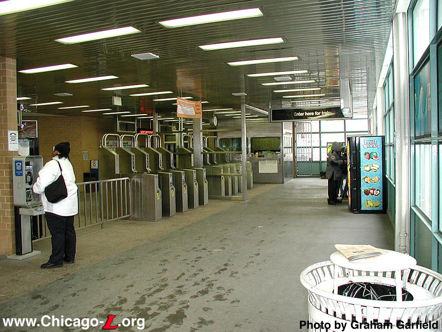
The Roosevelt elevated station auxiliary entrance is seen looking south on November 22, 2012, about a month after opening. The two high-barrier gate (HBG) turnstiles on the right provide ingress for passengers to the Orange and Green lines; the fencing on the left was eventually replaced with an exit rotogate. The brushed metal fascia with large lettering was inspired by the Belmont and Fullerton stations.
For a larger view, click here. (Photo by Graham
Garfield) |
The $650,000 project converted the auxiliary exit on the south side of Roosevelt Road into an auxiliary entrance, with direct access to the Green and Orange lines on the elevated station platform. The existing exit enclosure was gutted and partially demolished, with parts of the side walls reused and a new front facade added to the renovated facility. The new south entrance was equipped with High-Barrier Gate (HBG) turnstiles, which requires customers to already have a valid farecard to enter. Farecard vending machines and staff assistance continue to be available at the main entrance to the elevated station or in the subway station, both on the north side of Roosevelt Road. The project also included new lighting, new landscaping, and new signage.
The improvement allows customers to transfer from buses eastbound on Roosevelt Road directly to the elevated station without needing to cross Roosevelt Road, as well as provide more convenient access for residents of the South Loop. The entrance's new enclosure and projecting canopy adds shelter for customers waiting for eastbound buses.
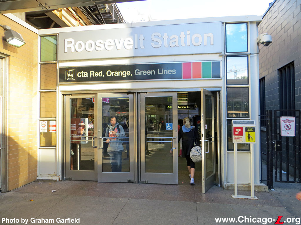
In addition, the entrance doorway of the main station house on the north side of Roosevelt Road received a new architectural identity treatment including new signage over the front doors, and new CTA "identifiers" were installed on the elevated track structure over Roosevelt Road to aid in the visibility of the station when approaching from a distance and to strengthen the station's identity. Mounted to the viaduct, each identifier includes a large CTA logo centered on a horizontal pole to attract attention from afar and provide remote identification of the station's location -- akin to the famous roundel that marks the entrance to London Underground tube stations. The CTA logo is flanked by bus and train symbols, denoting the transit services available at or adjacent to the station. Roosevelt's CTA identifier was the first of the viaduct-mounted type to the installed on the system (after the first a few months earlier at Granville), and the third overall to be installed after the backlit pole-mounted type added to the Roosevelt subway station in 2007.
Work on the project began in mid-June 2012. To stage the construction, the auxiliary exit on the south side of Roosevelt Road was temporarily closed and the eastbound bus stop near the south auxiliary exit was temporarily relocated. The rebuilt auxiliary entrance opened at 2pm, Wednesday, October 31, 2012. The identifiers were installed in mid-November 2012. The new signage and entrance treatment at the main station house was installed in mid-December 2012. Remaining work was completed by the end of 2012.
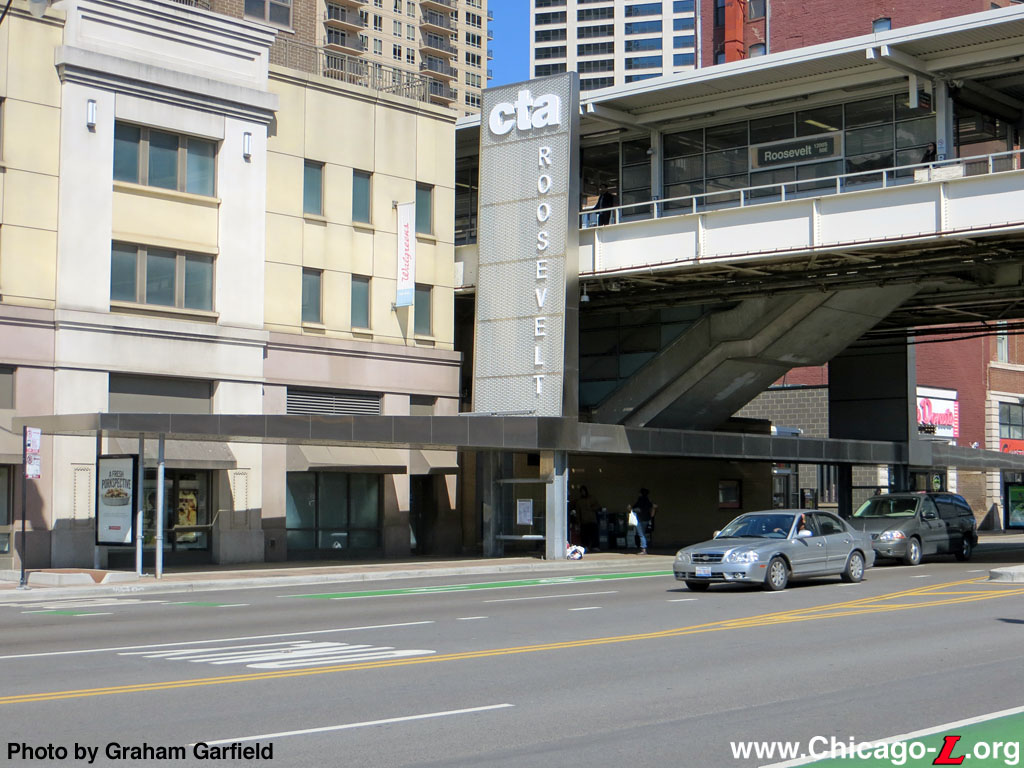
CDOT Streetscape Project
The pedestrian canopy over the sidewalk on the north side of Roosevelt Road, including the vertical identity pylon, are seen looking northeast on April 3, 2016.
For a larger view, click here. (Photo by Graham
Garfield) |
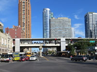
In June 2013, it was reported that the Chicago Department of Transportation (CDOT) was considering building a two-way bike lane on Roosevelt Road from State Street to Columbus Drive, providing a high-quality biking connection between the Roosevelt CTA station and Soldier Field, Museum Campus and Northerly Island. The buildout was envisioned as being more substantial, protected not by plastic poles or parking spaces but a line of trees. At the time, CDOT emphasized that the proposal is in its most preliminary stages -- "It's a little more than a thought," said CDOT spokesman Pete Scales, "but it's not fully baked."1
CDOT outlined plans for Roosevelt Road from State Street to Columbus Drive at a community meeting in September 2013.2 The concept had developed into a more substantial, holistic streetscape redesign of Roosevelt Road between State Street and Indiana Avenue. Still featuring a new protected two-way bike and pedestrian path lined by trees connecting the Roosevelt station and the southern end of Grant Park, the the path would include trees on a raised parkway protecting bikers and walkers from traffic, which is different than most protected bike lanes in the city. The plan included widening the sidewalks, planting trees, adding a paved walking path, inspirational messages in the ground to encourage people to head to Grant Park, and painting color-coded path indicators on the street.3
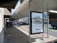
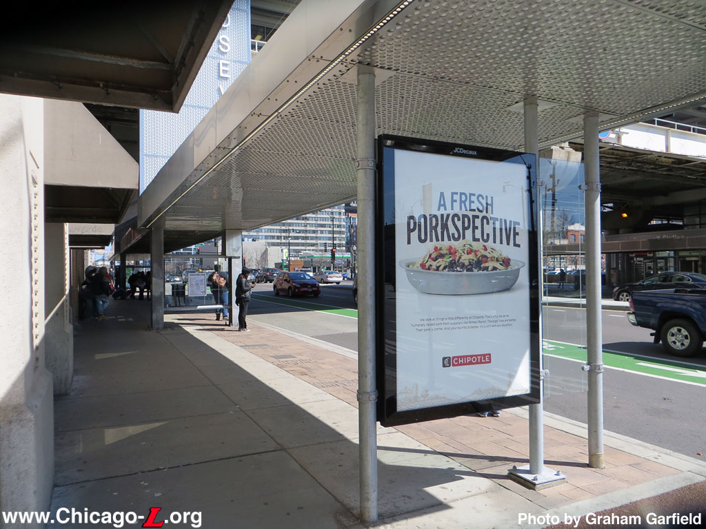
The pedestrian canopy over the sidewalk on the north side of Roosevelt Road is seen looking east on April 3, 2016. The canopy's columns, and especially the ad and glass screen panels, take up more than half the sidewalk width and as a result are obstructions to pedestrian flow and capacity.
For a larger view, click here. (Photo by Graham
Garfield) |
At the Roosevelt elevated station, the plans included additional infrastructure intended to provide additional weather protection for pedestrians approaching the station entrance mid-block between State and Wabash and for passengers waiting for buses outside the station on Roosevelt Road, as well as additional station identity. Canopies were to be built over the sidewalks on both the north and south sides of the street, projecting west toward State Street and east toward Wabash Avenue from the elevated track structure. Where the canopies meet the "L" structure, they swing upward and become tall steel pylons that project to the height of the roofs of passing trains. The pylons feature the "cta" logotype at the top and the station name "Roosevelt" vertically to provide remote identification for the station.4 (The station already had CTA-standard identifiers installed on the track structure over the street as part of 2012 improvement, making the identity function of these pylons somewhat duplicative.)
The sidewalk canopies and bus stop shelters are sufficiently long to not only cover the entire walk from the Roosevelt station entrance to the bus stop, but to provide protection for longer articulated buses (which commonly run on routes that serve the stop) or multiple standard-size buses at once (helpful, since the stops serve multiple routes whose buses may berth at the stop at once). The canopy's clearance is somewhat low, however, and include advertising panels spanning the canopies' support columns, which blocks half the width of the busy sidewalks, impeding pedestrian flow and capacity, as well as views of other people and street and sidewalk activity.5
The city also proposed to build a mid-block crosswalk between State and Wabash at the entrance to the Roosevelt "L" station, but the Illinois Department of Transportation (which has some jurisdiction over Roosevelt Road, even though it ceased being a publicly-numbered highway in 1972) resisted the idea.6
Crews began preliminary work on the new streetscape by June 2014, although major construction on the project wouldn't start until July 1. CDOT crews planned to begin at the west end of the project and work east, and planned to be done by Dec. 1.7 In fact, construction took more than a year, and was nearing completion in October 2015.8
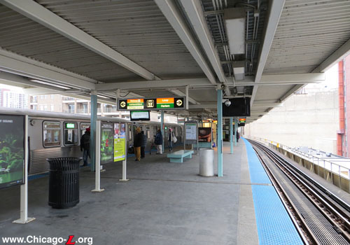
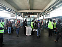
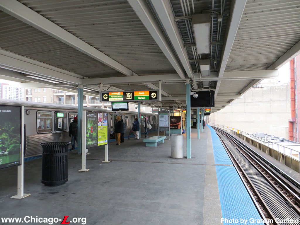
The wide island platform at Roosevelt station is seen looking north on December 31, 2012 as an Ashland/63rd-bound Green Line train stops. The platform is similar to those on the Orange Line with which it was contemporaneously designed and built, but with a flat canopy roof rather than the Midway branch's peaked ones. The backlit signage had been updated and information pylon added recently at the time of the photo. The canopy columns still retained there original sea-green color at this point, but the purlins, joists and roof had been repainted white. For a
larger view, click here.
(Photo by Graham
Garfield)
|

|
roosevelt-wabash04.jpg (45k)
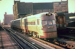
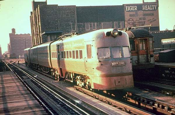
The North Shore Line made extensive use of the
Roosevelt Road station, especially after the "L" withdrew
service after which the NSL has exclusive use of the
facility. Here, a Silverliner loads passengers at one of the
side platforms while an Electroliner is laid up on the
center track. (Photo from the Joe Testagrose
Collection)
|
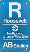 |
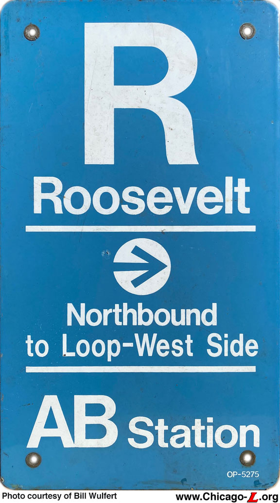
roosevelt-wabash-P-8_KDRsignNB.jpg (138k)
This "KDR"-style
symbol sign from the inbound side of the platform at Roosevelt is typical of this type and vintage -- large first letter of the station name with the full name under it; a "KDR arrow" pointing in the direction of travel with the direction and destination in the middle; and the skip-stop station type at the bottom. The color is also standard -- although in the original KDR signage system blue backgrounds were for 'AB' or All-stop stations, but this time the CTA had moved to a "Modified KDR" standard, wherein the color-coding was dropped and all station name and symbol signs were blue, CTA's corporate color. While most symbol signs were 12" x 18", there were two smaller, narrower variants designed to fit flush against the canopy columns without overhang at some stations. Roosevelt used the second variant, measuring 8.5" x 15", originally designed for the Kennedy-Dan Ryan stations (1969-70) and subsequently used at stations with wider columns including all the Southwest Transit Project (SWTP) stations (1993), which included Roosevelt. (Sign courtesy of Bill Wulfert) |
|
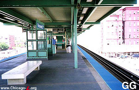
roosevelt-wabash03.jpg (68k)
The island platform at Roosevelt, looking south in 1999. In terms of design, the Roosevelt platform is very similar to the Orange Line stations built at the same time. It serves as a transfer point between the Orange and Green lines. (Photo by Graham
Garfield) |
|
roosevelt-wabash05.jpg
(175k)
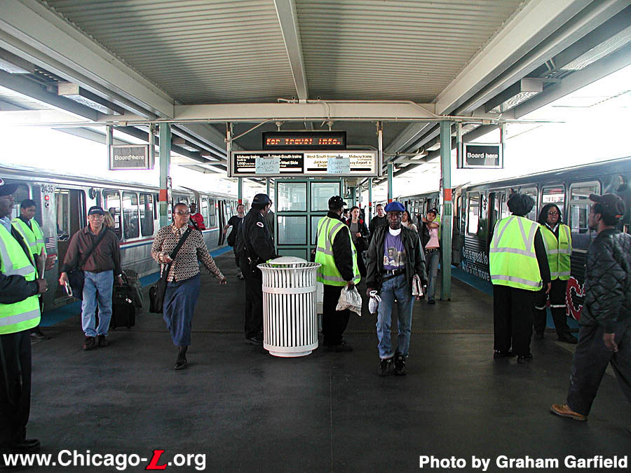
During the shutdown of Harrison Curve over Memorial Day
2003, Roosevelt/Wabash served as a stub terminal for
northbound Orange and Green line trains. The squad of vested
operating personnel, along with the paper signs on the
backlit sign, help passengers find their way in this view on
May 26, 2003. (Photo by Graham
Garfield)
|
|
roosevelt-wabash06.jpg (273k)
The Roosevelt auxiliary entrance is under construction in this westward-looking view on August 21, 2012. The enclosure from the old auxiliary exit has been demolished and the steel framework for the new entrance enclosure is being assembled. (Photo by Graham
Garfield) |
|
roosevelt-wabash09.jpg (304k)
The completed auxiliary entrance to the Roosevelt elevated station is seen on November 22, 2012, in this view looking west on the south side of Roosevelt Road. The modern-styled facility, with glass and metal curtain walls topped with a brushed metal fascia band with large identity lettering, provides access to the Orange and Green lines elevated platform for customers already possessing valid farecards. The doors on the left provide emergency egress or can be opening for additional entrance capacity during special events. The entrance provides convenient and safe station access for passengers transferring from the eastbound bus stop visible in the background without having to cross busy six-lane Roosevelt Road. (Photo by Graham
Garfield) |
 |
roosevelt-wabash11.jpg (216k)
As part of the 2012 improvement project that largely focused on renovating the south auxiliary entrance, the main Roosevelt station entrance on the north side of the street also got a minor facelift: the original rectangular backlit sign over the entrance doors was replaced with a brushed metal fascia panel with large lettering with the station name (matching one on the new auxiliary entrance facade) and a longer, narrower backlit sign with a graphic similar to the lower half of a standard station entrance sign with the line names and color bands, and the building's metal frame was repainted white. This view looks north on October 13, 2015. (Photo by Graham
Garfield) |
 |
roosevelt-wabash12.jpg (194k)
The Roosevelt station house interior paid area is seen looking south on October 13, 2015. A second escalator (going up) and set of stairs connecting to the elevated train platform is behind the one visible in the foreground, providing a large circulation capacity and escalators in both the up and down directions. The fare controls to the unpaid area and exit to Roosevelt Road is on the left; the elevator to the elevated platform and passageway to the Red Line subway are behind the photographer. (Photo by Graham
Garfield) |
 |
roosevelt-wabash13.jpg (223k)
The Roosevelt elevated station is seen in a vista of Roosevelt Road looking east from State Street on October 13, 2015, including the standard CTA Identifier added in 2012 and sidewalk canopies and vertical identity pylons added by CDOT in 2015. (Photo by Graham
Garfield) |
 |
roosevelt-wabash14.jpg (232k)
The canopy over the sidewalk on the south side of Roosevelt Road is seen looking south on October 13, 2015. The design of the canopy was poorly coordinated with the station improvements CTA made in 2012, as the height of the canopy blocks the lettering on the fascia of both station entrances. (Photo by Graham
Garfield) |
|
roosevelt-TransferTunnel01.jpg
(172k)
Construction on the Roosevelt transfer tunnel is well
advanced in this view looking northwest from the Roosevelt/Wabash
elevated station on March 21, 2002. The route of the
transfer tunnel, which was dug out from the surface and
covered with concrete roof decking, is clearly evident in
this view. (Photo by Graham
Garfield)
|
|
roosevelt-TransferTunnel02.jpg
(133k)
Looking west into the Roosevelt Transfer Tunnel on November
26, 2002 during a pre-opening inspection tour. The tunnel is
very wide at the east end, but narrows as it gets closer to
the Red Line station, due to space constraints of the
existing infrastructure. The design makes liberal use of
stainless steel. (Photo by Graham
Garfield)
|
|
roosevelt-TransferTunnel03.jpg
(146k)
The aesthetic concept for the tunnel is a time line of
history in conjunction with the three museums represented on
the Museum Campus: the Field Museum of Natural History, the
Shedd Aquarium, and the Adler Planetarium. The tunnel also
features a granite paver floor and a stainless steel ribbed
ceiling that almost resembles a mammal's ribcage and spine.
This view looks east on November 26, 2002, a week and a half
before the opening of the tunnel. (Photo by
Graham Garfield)
|
|
roosevelt-TransferTunnel04.jpg
(121k)
The walls of the tunnel itself displays a timeline of
history, from the Big Bang to space travel, with pictures
glazed into the tiles showing various plants, animals, and
celestial bodies. These are broken up by stainless steel
pilasters that mark the changeover between eras. Note the
Dimetrodon on the wall to the right of the pilaster on
November 26, 2002. (Photo by Graham
Garfield)
|
|
roosevelt-TransferTunnel06.jpg
(147k)
The vertical access between the tunnel and the Green/Orange
Line ground-level station house provides a cavernous and
open space where the "Hopes and Dreams" mural, created by
Juan Angel Chavez and Corrine D. Peterson of the Chicago Art
Group, is displayed. This view looks north from street level
on November 26, 2002. (Photo by Graham
Garfield)
|
|
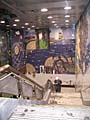
roosevelt_art01.jpg
(189k)
The Hopes and Dreams mural, as seen looking south
from street level, inside the entrance to the transfer
tunnel from the Orange/Green Line station.
For a larger view, click here. (Photo by Amy
Malick)
|
|
roosevelt_art02.jpg
(264k)
Detail view of Hopes and Dreams from the middle
landing of the stairs from the transfer tunnel to street
level. For a larger view, click
here.
(Photo by Amy Malick)
|

- roosevelt.wav
(16K): Station announcement for
Roosevelt/Wabash.
.
- Roosevelt-Orange.wav
(266k): "This is Roosevelt. Transfer to Red and Green Line
trains at Roosevelt. Thank you for riding the CTA Orange
Line." (Sound courtesy
of Tony Coppoletta)
Notes:
1. Schiffman Tufano, Lizzie. "City Mulling New Tree-Lined, Protected Bike Path for Roosevelt Road." DNAinfo Chicago, June 26, 2013.
2.
Maddox, Kristen and John Greenfield. "CDOT Reveals Plans for Chicago’s First Raised Bike Lane on Roosevelt Road." Streetsblog Chicago, September 27, 2013.
3.
Schiffman Tufano, Lizzie. "Roosevelt Road Bike Lane Construction Kicks Off." DNAinfo Chicago, June 6, 2014.
4.
Ibid.
5.
Vance, Steven. "Eyes on the Street: Roosevelt Bike Lane and Bus Shelters Nearly Complete. Streetsblog Chicago, October 5, 2015.
6.
Maddox and Greenfield, ibid.
7.
Schiffman Tufano, 2014, ibid.
8.
Vance, ibid.


