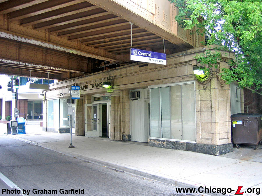
Central station is still
largely as-built at the time of the line's elevation, with
its 1931-vintage station house, bridge, and platform canopy.
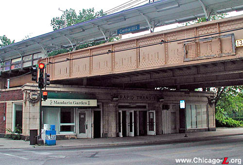
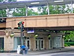
Seen in this July 26, 2003 view looking southwest is the
station's terra cotta facade -- with its classical features,
Doric columns, and glazed lettering over the entrance -- and
gull-wing canopy up top. For a larger view, click
here.
(Photo by Graham
Garfield)
|
Central
(2600N/1000W)
Central Street and Girard
Avenue, City of Evanston
Service
Notes:

|
Purple Line:
Evanston
|
Quick Facts:
Address: 1022 Central
Avenue, Evanston
Established: May 16, 1908
Original Line: Northwestern Elevated Railroad, Evanston
Division
Previous Names: none
Skip-Stop Type: All-Stop
Rebuilt: 1931
Status: In Use
History:
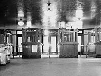
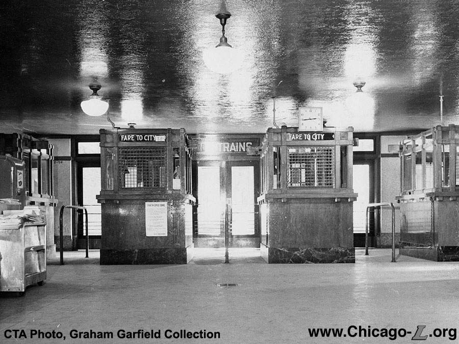
Above: The Central
station house, with its decorative if institutional pendant
lights and terrazzo flooring, originally had a row of four
ticket agents booths, as seen in this February 21, 1958
photo. They allowed the station to handle large crowds for
sporting events. Note that there are no turnstiles, even 10
years into the CTA era. For a larger view, click here. (CTA Photo, Graham Garfield
Collection)
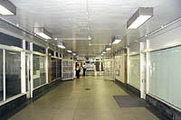
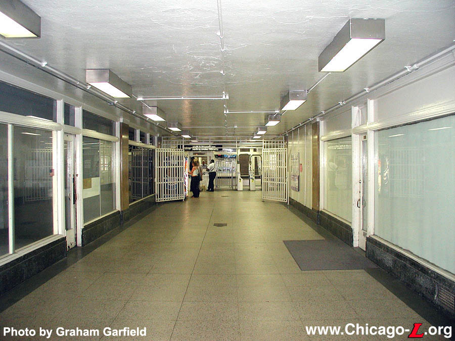
Below: The retail
spaces that flank the front entrance create a long corridor
between the front door and the fare controls, seen here
looking south on July 26, 2003. In the distance the fare
controls are visible, including the one remaining agents
booth of those seen above. For a larger view, click here. (Photo by Graham
Garfield)
|
"L" service was extended north of Wilson
in Chicago's Uptown neighborhood to Central Avenue in north Evanston
over the electrified tracks Chicago, Milwaukee & St. Paul
Railroad. The St. Paul had built the line, under the auspices of the
Chicago Evanston & Lake Superior Railway, as a commuter line to
Chicago Union Station and began service in 1889. They'd hoped to
continue north along the lake and meet the St. Paul main line near
Sulphur Glen (Rondout). But this never happened, traffic never
developed (thanks, in large part, to the parallel and competing
Chicago & North Western commuter line) and the St. Paul began
looking for ways to dump the service. The Northwestern Elevated
answered that call and took over operation of the line to Central
Avenue, Evanston on May 16, 1908.
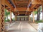
The Central Street terminal consisted of a simple high-level wooden
island platform and small headhouse at the north end of the platform
near the street. The tracks and station were at ground-level, as was
the entire Evanston extension of the Northwestern, as the "L" simply
electrified the existing ground-level steam railroad's tracks. A
small yard was built at Central Street, south of the station, for car
storage, although its capacity was modest. Central Street also served
as the main transfer point between the "L" and the Chicago &
Milwaukee Electric interurban (ancestor of the North
Shore Line). The
C&ME had already been leasing the St. Paul's tracks for a few
years from Linden Avenue in Wilmette to Church Street in downtown
Evanston, where their terminal was located just a block from the
"L"'s Davis Street station. Transfer was
also available to the Evanston Electric Railway Company's streetcar
line, which ran along Central and then south on Sherman to downtown
Evanston. (Later converted to motor buses, the line essentially
became the Evanston Bus Company's Route #1, then the
CTA's #201 Central-Sherman
bus, now the #201 Central-Ridge.)
By 1912, the Northwestern had outgrown its terminal at Central
Street. There were also new riders to be had in the nearby suburb to
the north, Wilmette. In February 1912, Northwestern President Britton
I. Budd notified Wilmette officials of his extension intentions and,
despite opposition that quickly developed, the line was extended on
April 1, 1912. The Central Avenue yard was soon closed and the
station's island platform was eventually replaced with a set of side
platforms. A station house was located at the north end of the
inbound platform.
Track Elevation and a New Station
The Evanston City Council had always wanted the line through the
city elevated and separated from street traffic and pedestrians, but
economics made it impossible to do all at once. The south half of the
line, from Howard Street to University Place, was elevated first in
1910. The final elevation of the North Side Division tracks through
north Evanston between University Place and the city limits at
Isabella Street was ordered by the city council in 1920, but
financing problems delayed the beginning of construction until 1928.
Construction began in August and was a joint venture between the
Chicago Rapid Transit Company (CRT), the North Shore Line, and the
Chicago Milwaukee & St. Paul (who still owned the right-of-way).
Trains were shifted onto a temporary two-level wooden trestle --
northbound trains on October 4th and southbound on December 9th --
with two-level stations while construction of the permanent
solid-fill embankment progressed. Work was largely finished by
1931.
A permanent station was built at Central Avenue as part of the
elevation project. Designed by Arthur U. Gerber, who also designed
the very similar Sheridan station on the
Howard line and South Boulevard in
south Evanston, this station combines elements of Doric and Beaux
Arts designs, executed in terra cotta. Trademark Gerber details
include the laurel-framed cartouches, pair of Greek Revival Doric
columns framing the entrance, globed lights and the words "Rapid
Transit" above the door in terra cotta. The interior is executed in
smooth art marble with a spacious fare control area. On the street
elevation, two retail spaces were provided on either side of the
entrance. Inside, these flanked the corridor that led to the fare
controls, which were located at the back of the building. The station
had multiple agent's booths to serve the large crowds that often came
to watch sporting events at Northwestern University's nearby Dyche
Stadium. The building remains historically intact, with its original
terrazzo floors, wood moldings, and one of its decorative agent's
booths.
The station was also designed with an auxiliary exit on the north
side of Central Street. Although this side had no headhouse, there
was a line of small ticket agent's booths that were manned during
period of high traffic (typically, a sporting event) when this exit
would temporarily be used as an auxiliary entrance. The booths have
since been removed and it now functions only as an auxiliary
exit.
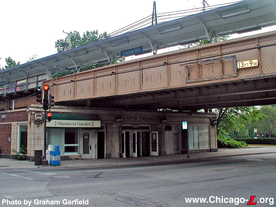
New
station-specific station entrance signs are seen in
front of Central station, hung from the steel
viaduct, looking southeast on July 23, 2005. For a
larger view, click here. (Photo by Graham
Garfield) |
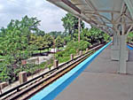
The station originally had two platforms, one island between the
two tracks and an additional side platform to the west of the inbound
track. The island platform was for the "L" and northbound North
Shore Line passengers, while the side platform was for southbound North
Shore Line riders. The idea was to separate inbound interurban
passengers so that they couldn't transfer to local "L" trains for
free. The stairs from this platform led to the unpaid area of the
station. There were no such concerns about "L" passengers boarding
northbound North
Shore Line trains, as the interurban had conductors
that would check for tickets. The platforms were originally decked with Haydite concrete slabs covered with 1"-thick asphalt planks. The island platform's steel canopy supports ran
down the center line and split into gently-curving gull wing-shaped
roof supports, supporting a wooden canopy roof. The side platform was
similarly designed, except that the supports lined the back of the
platform and simply arched out over the platform. The stairs were
sheltered by wooden enclosures with swinging doors at the front of
each enclosure. The disused North
Shore Line platforms at Foster, Noyes, and Central, which were abandoned when operation via the interurban's the Shore Line Route was discontinued
in 1955, were not removed until 1970, although their
concrete footings are still evident. The island platform is still in
use by "L" trains, though its asphalt flooring was later replaced with a concrete deck.
Central station remains largely intact, but in the 1990s
unfortunately lost its original light fixtures on the
Gerber-designed headhouse, replaced with modern, box-shaped
fixtures.
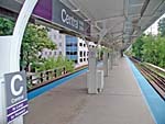
During May 2004, Central began receiving new platform
signage. The older KDR-type
station name signs were replaced with new Green Line
Graphic Standard versions. The thinner strap brackets
that held up the previous signs were replaced with more
substantial steel frames. Also replaced were the directional
wayfinding/Board Here signs, the long signs directing
passengers to which direction of service operates on which
side of the platform, at the top of each stair to the
platform. The first of the new station name signs and a few
symbol signs were installed at the far north end of the
platform at the same time. The rest of the station name
signs, column signs, and directional signs were installed
later.
In June 2005, new station entrance signs were added at
street level. Two signs were hung over the sidewalk from the
steel viaduct, one single-sided sign facing each direction
suspended from each side of the bridge near the corners of
the station house. The signs, conforming to a revised Green Line Graphic
Standard design, provide the name of the station and the
line serving it.
On July 15, 2011, the Chicago Transit Board today approved for tenants to occupy the concession space at Central station. The space will be occupied by a Dunkin'
Donuts store.The addition of this new contract, along with another lease for Ashland on the Orange Line, brings the total number of leased spaces at rail stations to 74. The lease agreements are with 2nd Gen. Inc owned by Chetan Jani. The lease agreement is for ten years and is expected to generate a combined $288,165 over the life of the contracts.
Red-Purple Lines Modernization (RPM) Project
Due to the deteriorating condition of the infrastructure on the Red Line north of Belmont and on the Purple Line, the CTA initiated the Red-Purple Modernization Project (RPM) to bring the existing transit stations, track systems, and structures into a state of good repair. The project, which stretches along the existing Red and Purple lines from north of Belmont station to Linden terminal, would help bring the existing transit line into a state of good repair, reduce travel times, improve access to job markets and destinations, and provide improved access to people with disabilities.
The project began in 2009 with a vision study to assess the scope of needs and develop a set of alternatives for study. In 2010, in accordance with the National Environmental Policy Act (NEPA), CTA and Federal Transit Administration (FTA) initiated the environmental review process for the project and undertook work to develop an Environmental Impact Statement (EIS). The process included numerous public meetings and input opportunities, and study of various alternatives for achieving a good state of repair for the infrastructure in the project area.
A number of alternatives are under consideration for the RPM project, including the comprehensive reconstruction of track, stations, and structures along the line. The four options currently under consideration and study, not including an FTA-required "no action" baseline scenario, include:
- Basic Rehabilitation: provides a strategic mix of repairs, rehabilitation, and replacement of the existing infrastructure for a useful life of 20 years, plus the addition of a transfer station at Loyola; all station locations remain the same.
- Modernization with Station Consolidation: provides a brand new elevated structure between Lawrence and Howard, modern amenities at stations, increases speed of service, includes new transfer station at Loyola, and major reconstruction and renovation to extend the useful life to 60-80 years; several stations would be consolidated by closing one station and adding a second entrance at an adjacent station.
- Modernization without Station Consolidation: provides a brand new elevated structure between Lawrence and Howard, modern amenities at stations, modest increase in speed of service, includes new transfer station at Loyola, and major reconstruction and renovation to extend the useful life to 60-80 years; all station locations remain the same.
Other alternatives considered earlier in the study but subsequently eliminated due to public comment and further study included basic rehabilitation without adding a transfer station at Loyola, a modernization option with only three tracks between Lawrence and Howard, and a modernization option with a 2-track subway under Broadway.
The full-scale modernization envisioned on the Red-Purple Modernization Project could cost anywhere from $2.5 to $5 billion. On February 8, 2012, the CTA board retained Goldman Sachs & Co. to lead the search for public-private partnerships to help finance the reconstruction, which has no firm date. Goldman Sachs will work with Chicago-based Loop Capital Markets LLC and Estrada Hinojosa & Co., but will accept no fee for the first year as it determines the ability to raise private capital.
See CTA's Red & Purple Modernization page for more information about the scoping and planning process, and the various alternatives being considered.
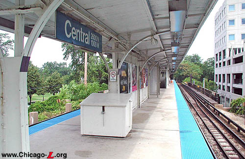
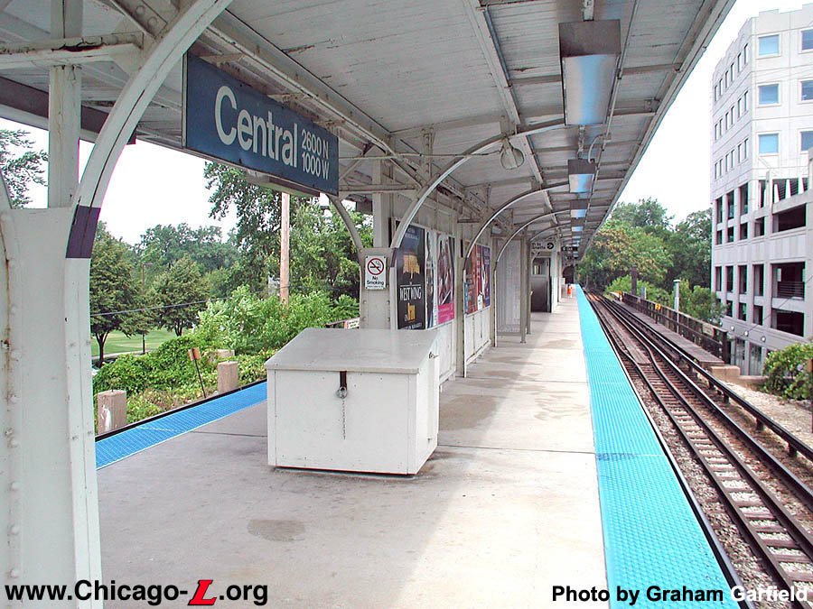
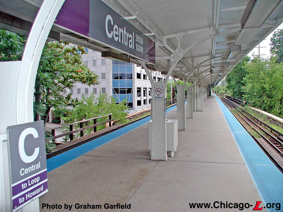
Central's island platform,
with its canopy supports that split into gently-curving gull
wing-shaped roof supports, is seen looking north on July 26,
2003. The original wood deck was later replaced with a
concrete floor. For a larger view, click here.
(Photo by Graham
Garfield)
|

|
central05.jpg
(207k)
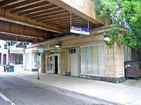
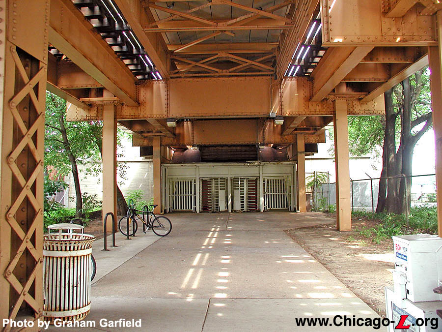
Across the street from the main entrance, on the north side
of Central Street, is an auxiliary exit from the platform.
Seen looking north on July 26 2003, the stairs are set quite
far back from the street, perhaps far enough that another
building could be erected between them and the street, if so
desired. To handle large crowds from nearby Dyche Stadium,
there used to be a row of small agent's booths in front of
the stairs that could allow this to be used as an auxiliary
entrance. The gates flanking the rotogates could be opened
to allow entry. The booths remained as late as the early
1970s. (Photo by Graham Garfield)
|
|
central06.jpg
(235k)
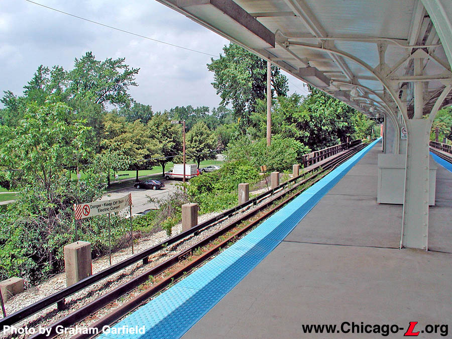
Still visible along the west side of the embankment, on the
outside of the inbound track, are the concrete footings for
the former North
Shore Line's separate side platform. This
view looks north on July 22 2004. (Photo by
Graham Garfield)
|
|
central07.jpg
(190k)
During late Spring and Summer 2004, Central station began to
receive new station name and column signs, as well as new
board here signs. These newly-installed Current
Graphic Standard signs are located at the north end of
the platform, seen looking south on July 22 2004.
(Photo by Graham Garfield)
|
|
central09.jpg
(196k)
With new station name and column signs on the platform
installed in spring 2004 and new station entrance signs
installed in summer 2005 give historic Central station an
up-to-date look -- and provide ample wayfinding information
for passengers -- in this July 23, 2005 view looking
southwest from the corner of Central and Girard.
(Photo by Graham Garfield)
|
|

|

|


