|
|
|
|
|
|
|
|
|
|
|
|
|
Published by: City of
Chicago Plan Summary: During the mid-1960s, the City of Chicago, the Chicago Transit Authority and other public agencies performed a joint study of central area development and transit demand, financed through interest-free funds provided by the Communities Facilities Administration at U.S. Department of Housing and Urban Development (USHUD). The study led to a central area transit plan whose goals were improve distribution of rapid transit and commuter railroad passengers in the Central Area, permit removal of the Loop Elevated structure, and to extend the rapid transit system to area of downtown Chicago not served to expand the boundaries of high-density development. In April 1968, a three volume report titled the Chicago Central Area Transit Plan was released, recommending the construction of a 15-mile subway system to replace the old elevated lines in downtown Chicago and allowing the demolition of the Loop Elevated. Two rapid transit routes were proposed:
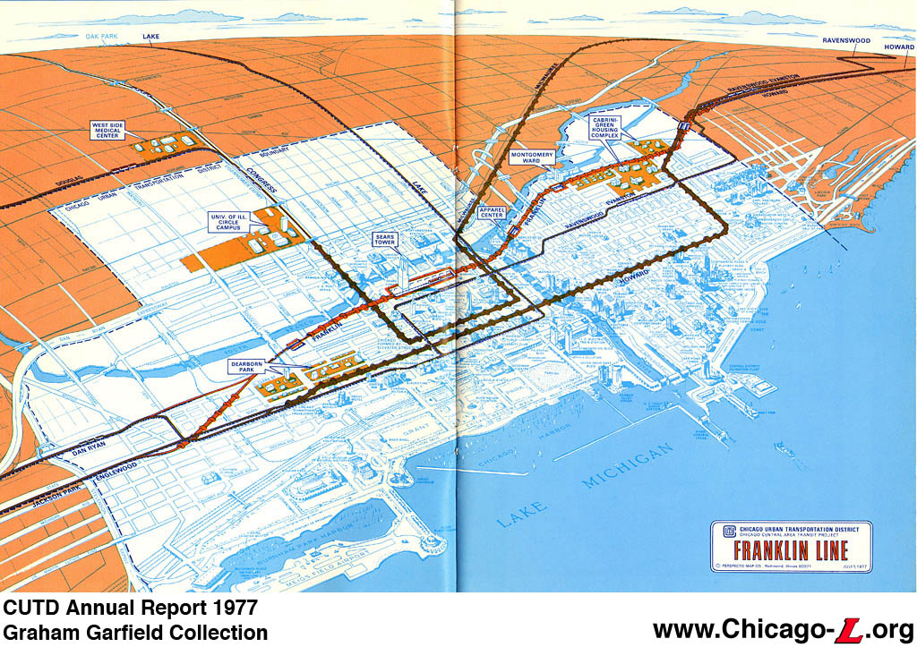
The plan called for subway construction to start in 1969, with the system opening in stages between 1973 and 1978. The Chicago Central Area Transit Project was formally adopted by the City of Chicago as part of the Comprehensive Plan of Chicago. In April 1970, the Chicago Urban Transportation District (CUTD) was created to implement the subway plan, overseeing design and construction. The CUTD had the power to levy taxes within the boundaries of the District -- North Avenue, Ashland Avenue, the Stevenson Expressway, and Lake Michigan -- to pay for some planning and other activities, although the bulk of the project's funding was expected to come from the federal government. The CUTD applied for federal funds, but the project was quickly mired in a series of delays. First, the validity of the plan was challenged, accusing the scheme of being "mode restricted" by assuming rapid transit to be the best technology for the plan's goals without studying other options. Consultants were retained to verify the assumptions and results of the 1968 Transit Planning Study, which was determined to indeed be valid. In 1973, the CUTD retained another consultant, American-Bechtel, Inc., to further review and refine the CCATP further study the details of the plan and conduct the necessary Environmental Impact Analysis. During this time, inflation began to rapidly increase the cost of the project. In 1974, the CUTD applied to the federal government for a facilities grant, proposing a 10-year project that would now cost $1.642 billion based on an annual escalation of 8% compounded to the mid-year of construction of each segment of the project. Given the scale of the project, both in terms of cost and the disruption to downtown that construction would cause, a staged plan for implementation was needed. Each route was studied to determine which legs would provide the fastest, best return on investment the and could be most easily integrated into the existing CTA "L" system. What emerged in 1974 was a Core Plan, an initial portion of the Chicago Central Area Transit Project to be built first, consisting of the Monroe Street Distributor as far east as Illinois Center, the Franklin Street Subway and a portion of the Randolph Street Subway. The Core Plan was projected to take about six years to complete and cost $1 billion (the cost was reduced to $700 million at the request if the Urban Mass Transit Administration [UMTA] but increased to $1.43 billion after UMTA withdrew the cost ceiling). The Balance of the Project, as the remaining lines were called, would be built at a later date. Pre-design work for the Monroe and Franklin lines began in 1974 and was completed in January 1976. By the mid-1970s, funding was becoming an increasingly big problem as costs soared and available funding shrank. The CCATP had to again be scaled down to meet more modest funding availability. Initially, only the Randolph Subway was removed from the Core Plan, but in June 1976 the decision was made to divide the Monroe and Franklin lines into separate projects. After studying each line, neither was determined to have any particular advantage or disadvantage over the other, so the Franklin Street Subway was chosen based on operating factors and the Monroe Distributor was put on hold. The Franklin Line was estimated to cost $496 million in 1977 dollars. The route was kept generally the same as the earlier plan, with a line beginning at Willow on the north and extending south under Clybourn, Larrabee, Kingsbury, Orleans, Franklin, and the proposed Franklin Connector expressway median. At the south end, connections would have been made with both the South Side Elevated and Dan Ryan Line. Stations were proposed for Chicago, the Apparel Center (Kinzie/Orleans) , a continuous platform in downtown (the Sears Tower was built to accommodate basement-level access to the subway station), and Roosevelt. Through-routed Ravenswood-Englewood-Jackson Park trains were planned to use the new subway, as well as Evanston Express trains that would turn from south back to north at Roosevelt Road via a planned middle track. Lake Street trains would be left to use the Loop Elevated until the financial situation allowed work to begin in the Monroe Street Distributor. The Balance of the Project (the remaining lines from the original CCATP), now only a vague notion, was slated to be constructed at an indeterminate future date. Work was to begin on the Franklin Street Subway in January 1979 and was scheduled for completion in December 1983. The CUTD prepared to begin work on the Franklin Street Subway, beginning the process of selecting contractors and undertaking initial tasks such as taking soil core samples. But then an interesting thing happened: some people began to talk of keeping the Loop Elevated. The reasons for doing so were varied, depending on who was advocating it: some felt the CCATP was too expansive and didn't provide enough return on the investment, other felt that the Loop structure was sound and with improvement could continue to serve its original function, and still others felt the Loop was a historic landmark of engineering and Chicago development and should be preserved. Some compared the Loop's cultural impact and association with Chicago to San Francisco and its cable cars, while the Chicago Chapter of the American Institute of Architects compared the engineering significance of the elevated structure to that of the Eiffel Tower. The arguments for and against keeping the Loop took an urgent turn in February 1977, when a Lake-Dan Ryan train collided with a Ravenswood train at Lake and Wabash and fell from the structure, killing 11 people and injuring dozens of others. Many of those who backed the Franklin Street Subway and other CAATP projects pointed to the accident as another example of the Loop Elevated's outdated design and lack of safety. Most media outlets, several government agencies (including the RTA and CATS), and area business organizations came out in favor of replacing the Loop with the subways, and for a time it seemed to give the project a boost. But soon the furor died down and more pragmatic factors dictated the fate of the CCATP. As 1979 marched on, little progress was being made but funds continued to be spent and the total cost of the project continued to increase. Other transit projects then either underway or in advanced stages of design, particularly the O'Hare Extension and the Southwest Transit Project (opened as the Orange Line), were in need of funds. At the same time, another long-planned but controversial project, the Crosstown Expressway, was also mired in delays, debate, and increasing costs. Determining the Franklin Street Subway (and the rest of the CCATP) to be a lost cause, former Chicago mayor Jane M. Byrne and former Illinois governor James R. Thompson reached an agreement in June 1979 to cancel the Franklin Line Subway project (and the Crosstown Expressway) and "de-designate" the money. The funds, amounting to approximately $2 billion, were transferred to an Interstate Transfer Fund.
The Results: The Loop Elevated was retained and a plan was developed to rehabilitate its structure and stations. The Loop Elevated was determined to eligible for the National Register of Historic Places, although the stations were not subject to this determination (with two exceptions, below). Using some of the Interstate Transfer Funds, work began in 1982 to repair and improve the elevated structure, replacing deteriorated members, refurbishing the existing steel, and repainting it. Stations were also slated for either rehabilitation or replacement, and in same cases new stations were to be added. The Quincy station was chosen to be restored to near its original 1897 appearance, which was done in 1985-88. Adams/Wabash was programmed to have its basic structure retained, but renovated and improved; this was done according to a plan developed by Harry Weese in 1987-89. The remaining stations were to be rebuilt and the total number equalized at two per side. This meant adding a station at State/Van Buren (replacing one that had closed in 1973) and consolidating the Randolph and Madison stations on both the Wabash and Wells sides into one station on each leg at Washington. Clark/Lake station was completely rebuilt in 1989; Randolph/Wells and Madison/Wells were consolidated into Washington/Wells in 1995, and a new station at State/Van Buren (originally to be called Library Place in the 1981 Loop plan, but opened as Library-State/Van Buren) opened in 1997. New stations at State/Lake and a consolidated station at Washington/Wabash are planned but yet to come to fruition. No plans have been set forth to renovated or rebuild LaSalle/Van Buren. The remainder of the Interstate Transfer Fund was used for a variety of other highway and transit infrastructure projects in the Chicagoland area, including several other "L" projects. Money from the Fund was used to pay for constructing the O'Hare Extension (opened in 1983-84), the Southwest Transit Project (opened as the Orange Line in 1993), and the Howard-Dan Ryan connector subway (opened in 1993). The Fund had been completely used by the 1990s. The Chicago Urban Transportation District, whose sole purpose had been the planning and construction of the Chicago Central Area Transportation Plan, stuck around for a few more years after the project was canceled, doing some planning work and tying up loose ends. But, with its central purpose gone and little support for a new central area transit project, the CUTD was dissolved in 1983. Interestingly, although the city seemed to be uninterested in pursuing the CCATP, Chicago city planners developed a new citywide transportation plan (with several projects for the central area). Although the project was more diffused around the city, the $1.12 billion plan, titled "Transportation Necessities", was hardly a modest program. Mayor Byrne's Architectural Advisory Committee included several transit proposals in the program, which included:
The Chicago Transportation Study (CATS) adopted these plans and included them in their Year 2000 Transportation System Development Plan, along with a few additional proposals. Most of the projects, except for the Loop renovations and Southwest Line, were left on the drawing board. In the 1990s, the streetcar proposal was resurrected as the Central Area Circulator, which proposed several streetcar/light rail lines in the central area. But the project ultimately collapsed under the weight of political haggling and a lack of consensus. . |
|
|
. .
Map of the central Chicago, showing the existing "L" lines and the recommended routes for the Loop, Franklin, and Monroe Distributor subways. Click image for larger view. (Image from Chicago Central Area Transit Planning Study, 1968, from the Graham Garfield Collection)
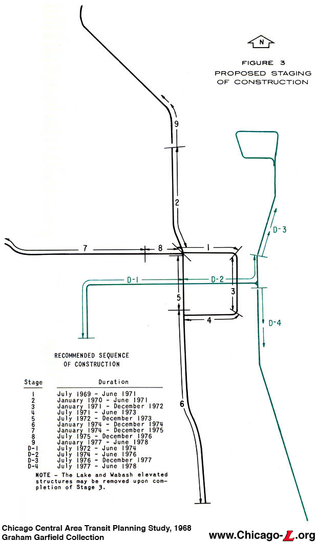
Original 1968 staging plan for the Central Area subways, including the projected dates of construction. The timeline would quickly change. Click image for larger view. (Image from Chicago Central Area Transit Planning Study, 1968, from the Graham Garfield Collection)
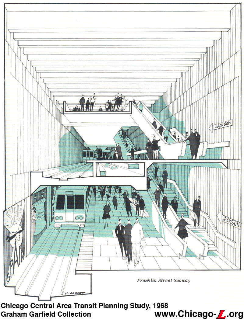
Artist's rendering cutaway of the proposed Franklin Avenue Subway, which was proposed to be a two-level subway downtown to contain the tunnel in a narrow right-of-way. Click image for larger view. (Image from Chicago Central Area Transit Planning Study, 1968, from the Graham Garfield Collection)
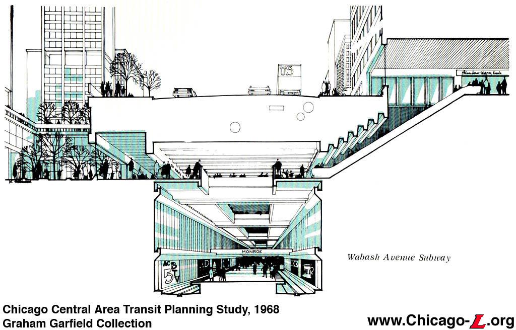
Artist's rendering cutaway of the proposed Wabash Avenue Subway at Monroe Street. Note the oversized "super-graphics" typical of the 1970s. Click image for larger view. (Image from Chicago Central Area Transit Planning Study, 1968, from the Graham Garfield Collection)
Artist's rendering cutaway of the proposed Wabash Avenue Subway at Monroe Street. It was intended for the new subways to be integrated with new downtown developments, plazas, and underground walkways. Click image for larger view. (Image from Chicago Central Area Transit Planning Study, 1968, from the Graham Garfield Collection)
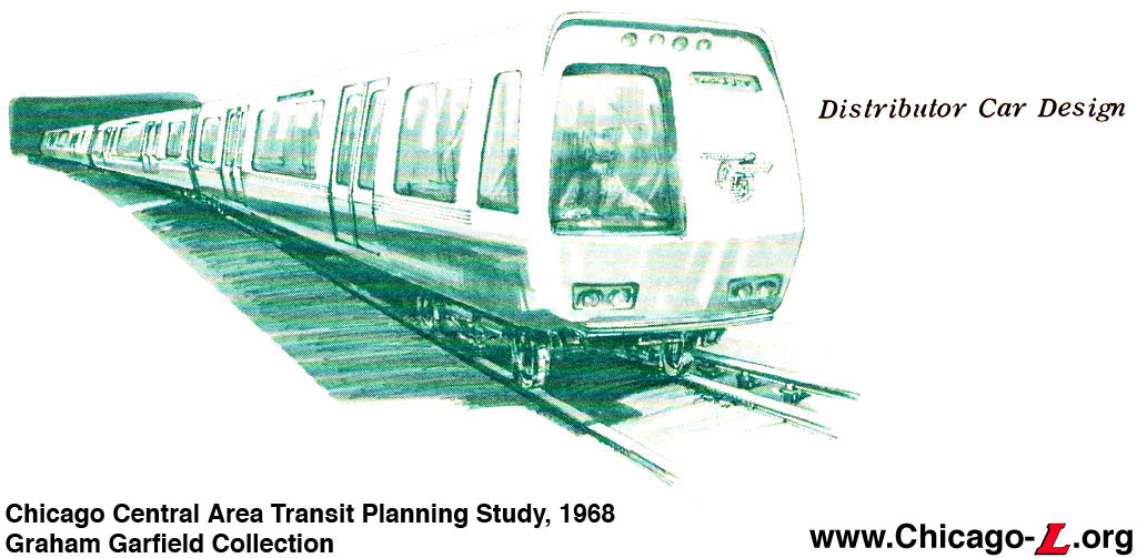
Proposed car design for the Monroe Street Distributor subway. Although all of the CCATP subways were designed to accommodate standard "L" cars, a new three-unit articulated car design with six doors per side was recommended for the Distributor subways to aid in quick loading and unloading for fast movement. Click image for larger view. (Image from Chicago Central Area Transit Planning Study, 1968, from the Graham Garfield Collection)
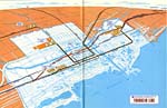
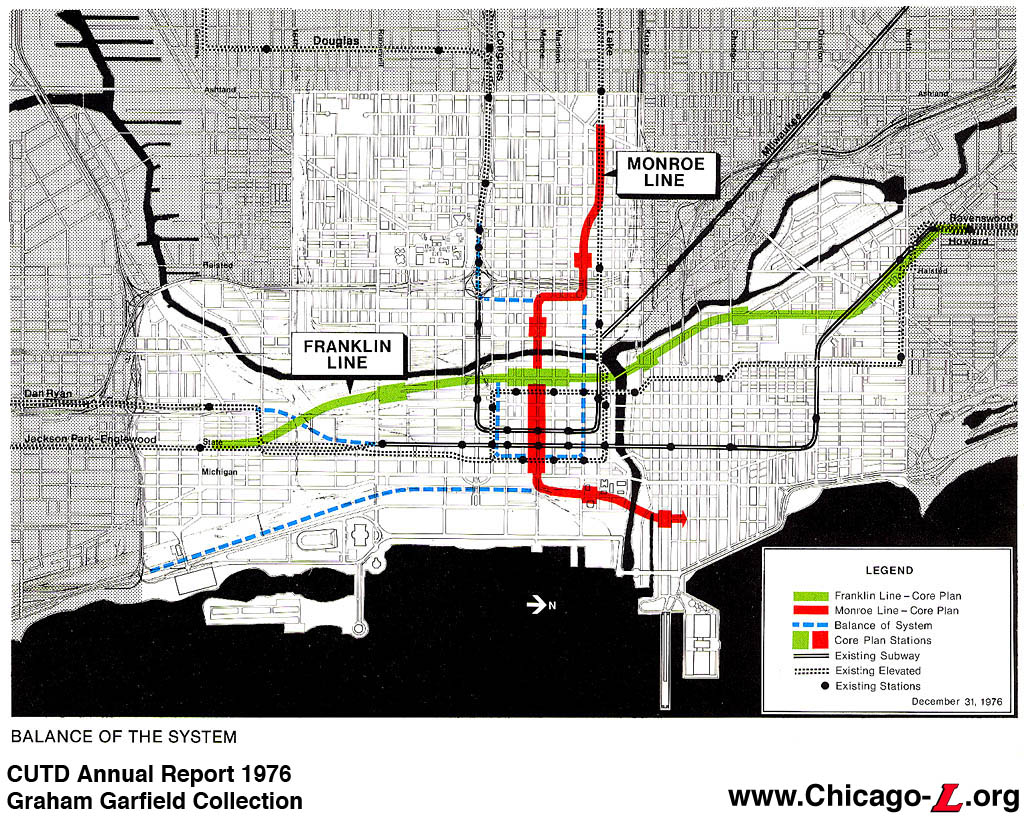
Map of the proposed system in 1976, showing the Franklin and Monroe lines (the latter altered to connect to Lake Street). The rest of the original plan has been relegated to "Balance of System" status for later implementation. Click image for larger view. (Image from CUTD 1976 Annual Report, from the Graham Garfield Collection) |
|
 |
CUTD-SubwayKiosk.jpg
(267k) |
 |
CUTD-1974MonroeLine_mezz.jpg
(173k) |
 |
CUTD-1975entrancemodel.jpg
(157k) |
 |
CUTD-1977FranklinMap.jpg
(315k) |
|
|
|


