|
|


|
|
|
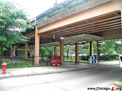
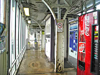
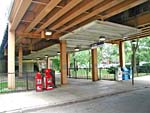
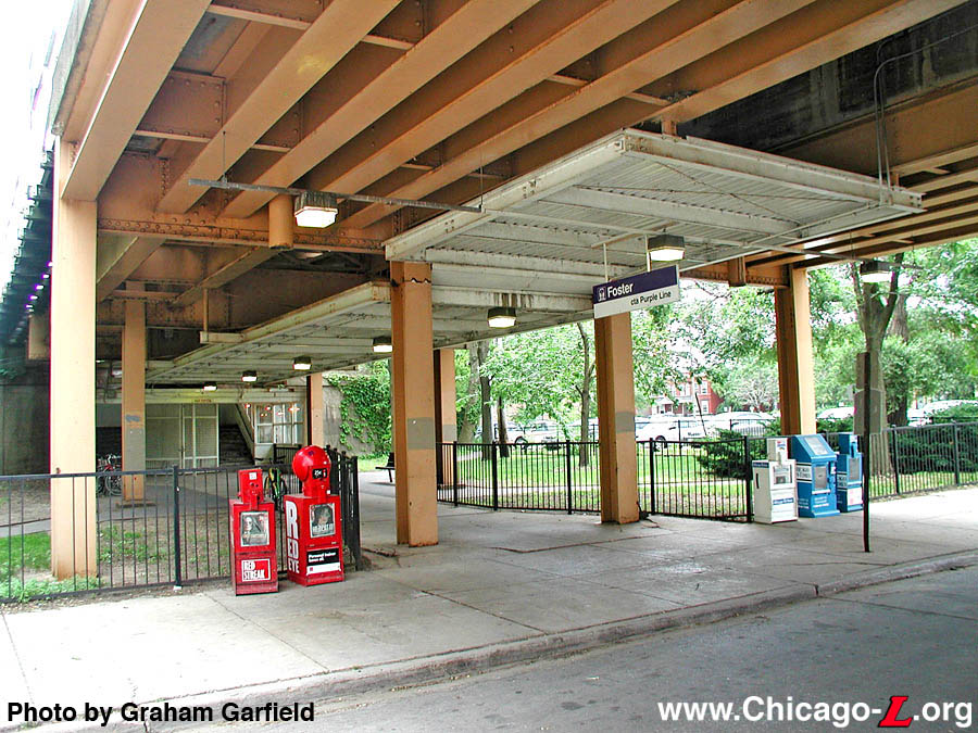
Foster station is seen looking southwest on June 14, 2005, with the platform and gullwing canopy above and entranceway underneath the viaduct. For a larger view, click here. (Photo by Graham Garfield) |
|
|
|
|
|
|
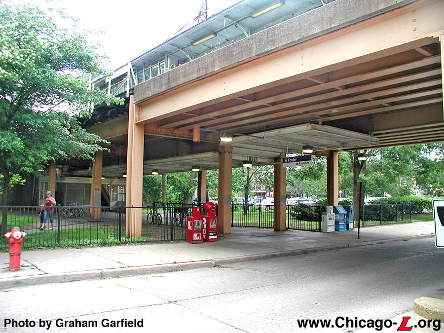
Foster station is seen looking southwest on June 14, 2005, with the platform and gullwing canopy above and entranceway underneath the viaduct. For a larger view, click here. (Photo by Graham Garfield) |
Foster
(2000N/900W)
Foster Street and Maple
Avenue, City of Evanston
Service Notes:
Purple Line: Evanston
Quick Facts:
Address: 900 Foster Street
Established: January 6, 1909
Original Line: Northwestern Elevated Railroad, Evanston branch
Previous Names: none
Skip-Stop Type: All-Stop
Rebuilt: 1931
Status: In Use
History:
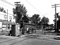
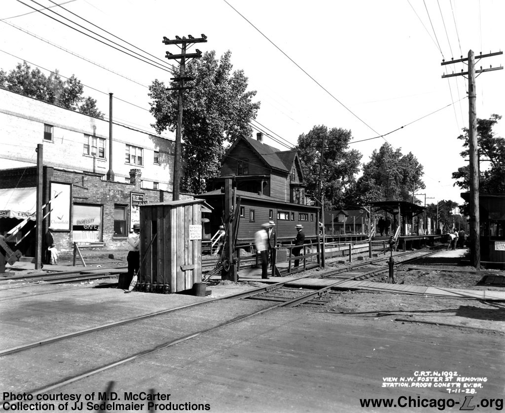
The original wooden station house at Foster is seen looking northwest on December 11, 1928. The station was originally between the tracks, but was moved to the side and side platforms substituted as part of the phasing for the track elevation project. For a larger view, click here. (Photo courtesy of M.D. McCarter, Collection of JJ Sedelmaier Productions) |
"L" service first entered north Chicago and Evanston by way of an agreement to use the tracks of the Chicago, Milwaukee and St. Paul Railway's tracks, replacing the steam service that the St. Paul had previously provided. The Evanston City Council authorized the electrification of the tracks of the Chicago, Milwaukee and St. Paul Railroad's tracks in their city in March 1907, but also required that the grade-level tracks be elevated between Howard Avenue at the south city limits and University Place at the north end of downtown by the end of 1910. "L" service north of Wilson to Central Avenue in Evanston began on May 16, 1908.
Most of the locations where the "L" would have stations were also stops on the St. Paul, but Foster was an exception -- there was no St. Paul depot at Foster Street. The Northwestern Elevated added a stop at Foster, but because of construction delays the station didn't open until January 6, 1909, approximately eight months after the Northwestern "L" began service over the line.
The "L" station facility at Foster was a simple ground-level station and modest platform. The station house was a small, wood frame building set between the two tracks at ground level with a wooden walkway and stairs leading up to it from the street. The exterior used clapboard siding and a hipped roof with eaves. The rear opened out onto an island platform. The platform had a short canopy with a hipped roof (which was actually a continuation of the station house's roof) and center wooden columns with angled brackets, and wood decking.
Track Elevation and a New Station
The Evanston City Council had always wanted the line through the city elevated and separated from street traffic and pedestrians, but economics made it impossible to do all at once. The south half of the line, from Howard Street to University Place, was elevated first in 1910. The final elevation of the North Side Division tracks through north Evanston between University Place and the city limits at Isabella Street was ordered by the city council in 1920, but financing problems delayed the beginning of construction until 1928. Construction began in August and was a joint venture between the Chicago Rapid Transit Company (CRT), the North Shore Line, and the Chicago Milwaukee & St. Paul (who still owned the right-of-way). Trains were shifted onto a temporary two-level wooden trestle -- northbound trains on October 4th and southbound on December 9th -- with two-level stations while construction of the permanent solid-fill embankment progressed. Work was largely finished by 1931.
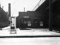
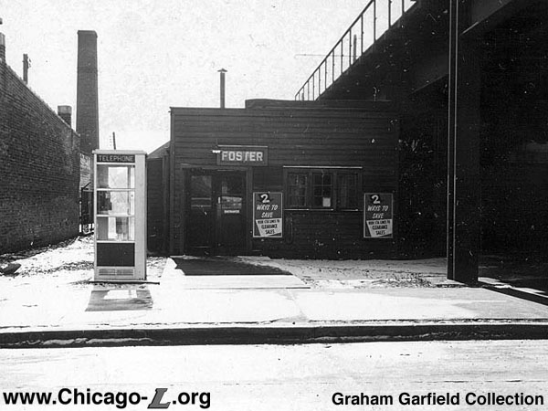
The "temporary" wooden station house at Foster, which was used for over 30 years, is seen looking south on February 11, 1957. The building was a very rudimentary wood-frame structure clad in wood panelling, with an enclosed corridor leading from the rear to the stairs up to the platform. For a larger view, click here. (Photo from the Graham Garfield Collection) |
Foster and Noyes stations were rebuilt in 1931 at the same time as Central, when the line was elevated through north Evanston. There were Beaux Arts station houses that were similar to Central's designed for Noyes and Foster by Chicago Rapid Transit Company architect Arthur Gerber, but they were never built. Instead, there were "temporary" wooden station houses below the tracks at Noyes and Foster on the present sites of the walkways from the street to the stairs up to the platforms, across from where the permanent station houses would've been. These temporary station houses were removed in 1964, when the fare controls were moved up to platform level.
The station originally had two platforms, one island between the two tracks and an additional side platform to the west of the inbound track. The island platform was for the "L" and northbound passengers of the North Shore Line, a interurban that entered Chicago via trackage rights on the Evanston and North Side "L" lines, while the side platform was for southbound North Shore Line riders. The idea was to separate inbound interurban passengers so that they couldn't transfer to local "L" trains for free. There were no such concerns about "L" passengers boarding northbound North Shore Line trains, as the interurban had conductors that would check for tickets. The platforms were originally decked with Haydite concrete slabs covered with 1"-thick asphalt planks. The island platform's steel canopy supports ran down the center line and split into gently-curving gull wing-shaped roof supports, supporting a wooden canopy roof. The side platform was similarly designed, except that the supports lined the back of the platform and simply arched out over the platform. The stairs were sheltered by wooden enclosures with swinging doors at the front of each enclosure. The disused North Shore Line platforms at Foster, Noyes, and Central, which were abandoned when operation via the interurban's the Shore Line Route was discontinued in 1955, were not removed until 1970, although their concrete footings are still evident. The island platform is still in use by "L" trains, though its asphalt flooring was replaced with a concrete deck circa the late 1960s.
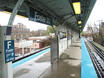
The platform-level fare controls at Foster are seen looking north from the top of the stairs from street-level on April 22, 2005. Never intended to accommodate a fare control area, circulation here is tight but sufficient for the ridership levels the station typically sees. For a larger view, click here. (Photo by Graham Garfield) |
In 1996, the CTA moved beyond the demonstration period of its new TransitCard Automatic Fare Collection (AFC) equipment and fare media and began installing AFC equipment at all of the rail stations. The first in-service station to receive the machines was Foster on the Purple Line. On March 29, 1996, the southbound berthing markers at Foster and the northbound markers at Noyes were relocated at 1500 hour to make room for the installation of the AFC equipment. The turnstiles at Foster were installed by Cubic personnel on April 9, 1996. AFC equipment was installed elsewhere around the "L" system throughout 1996 and fare collection completed migrating to the new system in 1997.
During mid-2005, Foster began receiving new signage. In June 2005, new station entrance signs were added at street level. Double-sided sign was hung over the sidewalk from the viaduct in front of the walkway to the station entrance. The signs, conforming to a revised Green Line Graphic Standard design, provide the name of the station and the line serving it. The next month, the older KDR-type station name signs and station symbol signs on the platform were replaced with new Green Line Graphic Standard versions. Also added were new directional wayfinding/Board Here signs, the long signs directing passengers to which direction of service operates on which side of the platform, at the top of each stair to the platform.
Red-Purple Lines Modernization (RPM) Project
Due to the deteriorating condition of the infrastructure on the Red Line north of Belmont and on the Purple Line, the CTA initiated the Red-Purple Modernization Project (RPM) to bring the existing transit stations, track systems, and structures into a state of good repair. The project, which stretches along the existing Red and Purple lines from north of Belmont station to Linden terminal, would help bring the existing transit line into a state of good repair, reduce travel times, improve access to job markets and destinations, and provide improved access to people with disabilities.
The project began in 2009 with a vision study to assess the scope of needs and develop a set of alternatives for study. In 2010, in accordance with the National Environmental Policy Act (NEPA), CTA and Federal Transit Administration (FTA) initiated the environmental review process for the project and undertook work to develop an Environmental Impact Statement (EIS). The process included numerous public meetings and input opportunities, and study of various alternatives for achieving a good state of repair for the infrastructure in the project area.
A number of alternatives are under consideration for the RPM project, including the comprehensive reconstruction of track, stations, and structures along the line. The four options currently under consideration and study, not including an FTA-required "no action" baseline scenario, include:
The Modernization with Station Consolidation option includes the consolidation of Foster station with the Davis and Noyes stations by closing the existing Foster station and adding entrances to Davis and Noyes -- at Church Street for Davis station, at the north end of Davis station and approximately five blocks south of Foster station; and at Gaffield Place, approximately three blocks north of Foster station and one block south of Noyes station.
Other alternatives considered earlier in the study but subsequently eliminated due to public comment and further study included basic rehabilitation without adding a transfer station at Loyola, a modernization option with only three tracks between Lawrence and Howard, and a modernization option with a 2-track subway under Broadway.
The full-scale modernization envisioned on the Red-Purple Modernization Project could cost anywhere from $2.5 to $5 billion. On February 8, 2012, the CTA board retained Goldman Sachs & Co. to lead the search for public-private partnerships to help finance the reconstruction, which has no firm date. Goldman Sachs will work with Chicago-based Loop Capital Markets LLC and Estrada Hinojosa & Co., but will accept no fee for the first year as it determines the ability to raise private capital.
See CTA's Red & Purple Modernization page for more information about the scoping and planning process, and the various alternatives being considered.
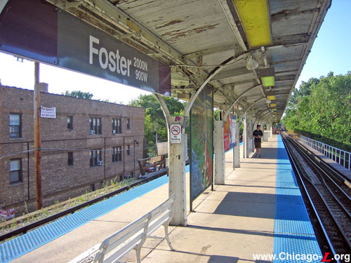
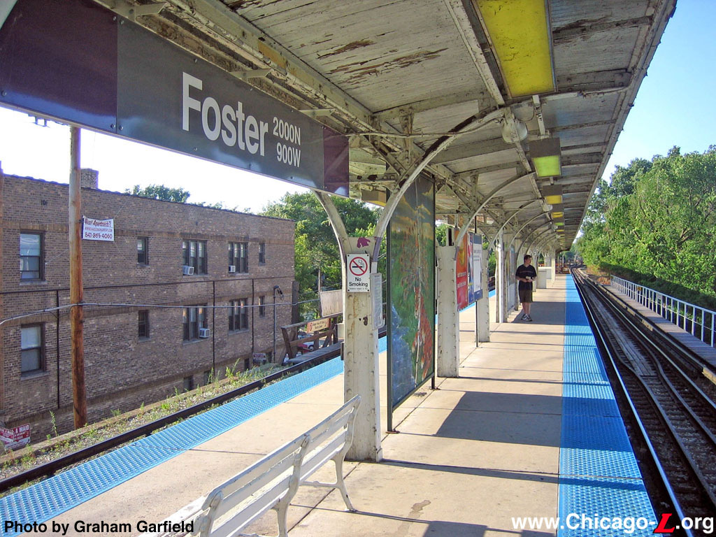
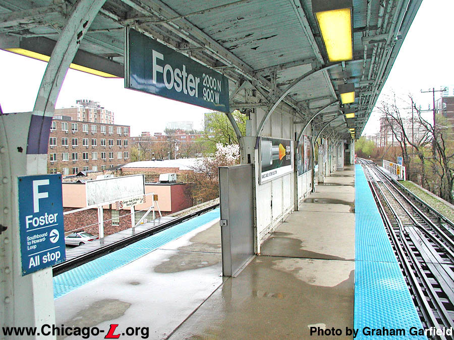
Foster station's island platform is seen looking north on July 24, 2005. The gullwing canopy with wood the wood-panelled underside is typical of the stations built for the 1931 elevation project in north Evanston. The station signage was updated in 2005. For a larger view, click here. (Photo by Graham Garfield) |
 |
foster03.jpg (221k) |
 |
foster05.jpg
(202k) |
 |
foster07.jpg
(206k) |
|
|
|