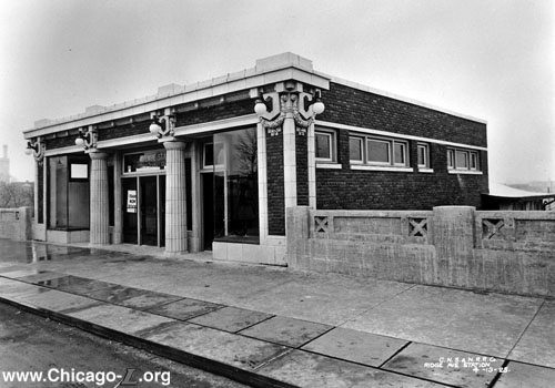
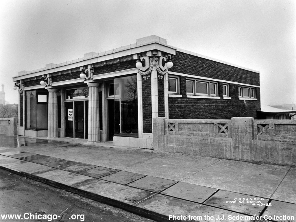
The Beaux-Arts Ridge station
house, looking northeast on April 13,1925, a couple weeks after service began. The station house
resembled many of Arthur Gerber's other Beaux-Arts designs
on the "L" such as South
Boulevard and
Sheridan
from the street, but was rather unique from the track-side
view. For a larger view, click here. (Photo
from the J.J. Sedelmaier Collection) |
Ridge
(1000W/200N)
Ridge Avenue and Brummel
Street, City of Evanston
Service
Notes:

|
North Side
Division: Skokie branch
|
Quick Facts:
Address: 215-217 Ridge Avenue
Established: March 28, 1925
Original Line: North Side Division: Niles Center branch
Previous Names: none
Skip-Stop Type: n/a
Rebuilt: n/a
Status: Demolished
History:
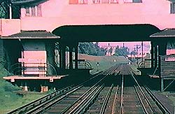
A closer view of
the platforms at Ridge. These short platforms could
only hold, at most, two CRT cars. The stairs from
the station house are in enclosures at the
foreground of the platforms. The circular bend of
the ends of the platform railings is typical on the
"L", seen at many stations, like Morse for instance. (Photo from North Shore Line, from Sunday River
Productions) |
When the Yellow Line first operated
as the Niles Center branch of the Chicago Rapid Transit Company
(1925-1948), there were a number of stops between the two
terminals. This was one of three stations in Evanston (the
others were Asbury and Dodge)
on the east-west leg of the Niles Center branch.
Ridge station's entrance was located on the bridge over
the tracks. While the tracks below carried trains of both the "L" and the North Shore Line interurban, only "L" trains stopped at the station. Designed by Arthur U. Gerber, the station had an
clever mix of styles. The front and side elevations,
visible from the street, were designed in a style familiar to many "L" riders, resembling stations Gerber
designed at Sheridan, South
Boulevard, and Central among
other locations. The building combined elements of Doric and Beaux Arts designs,
executed in Terra Cotta. Trademark Gerber details included
the laurel-framed cartouches, pair of Greek Revival Doric
columns framing the entrance, globed lights and the words
"Rapid Transit" above the front door in terra cotta. The
interior was executed in smooth art marble with a spacious
fare control area. On the street elevation, two retail
spaces were provided on either side of the entrance. Inside,
these flanked a corridor that led to the fare controls,
which were located at the back of the building.
The rear elevation of the building, however, was a
distinctively different style. Encompassing elements such as
a stucco exterior, arched windows, and tile roofs over the
stairs and platforms, the design of the rear elevation is
largely influenced by the Mediterranean style. This
Spanish-influenced style makes sense, as the North Shore Line stations on the same line north of Dempster used this style. Thus, Gerber designed the
Ridge station such that from the street it resembled the
typical stations he was designing for the rapid transit
system at that time, but from track level it resembled the
other stations on the North Shore Line, whose trains passed
the station.
The station had short, dual side platforms which could
accommodate no more than two or three "L" cars at a time.
The west ends of the platforms were covered by the street
viaduct, while the east ends were protected by the depot
building overhead and hipped roofs that projected from the
underside of the building. Stairs lead from the station
house's rear to the east end of the short platforms.
On March 27, 1948, the
CTA abandoned service
over the Niles Center Line, closing the station and replacing the "L" service with the #97 Skokie bus route.
The North Shore Line abandoned their Skokie Valley Route (including the former Niles Center Line "L" tracks) in
January 1963, though the Ridge station hadn't been in service since March 1948.
Following the abandonment of the North Shore Line, the CTA began to pursue the reactivation of the tracks as far north as Dempster, the same stretch served by "L" trains between 1925 and 1948. Funded as a "demonstration project" for a duration of two years beginning in April
1964 by the Department of Housing and Urban Development, the reestablished service, coined the Skokie Swift, was a nonstop shuttle
between Howard at the
Chicago city limits and Dempster in Skokie. All of the
intermediate stations were to remain closed and local service would
continue to be provided by the #97 Skokie bus. Ridge station's demolition wasn't included in the budget of
the Skokie Swift's construction (though Main, Oakton, Kostner and East Prairie were),
and the station survived until 1970. After closure, the
small one-story station house was converted into a
commercial structure. This ornate building at one point
housed a candy store. By the 1980s, the station building was
completely gone and the bridge rebuilt.
Ridge station served St. Francis Hospital a few blocks north,
which still operates.
A New In-fill Station in South Evanston
Discussion of adding local stations between Howard and Dempster began almost immediately after the Skokie Swift began operations in 1964.
Serious study of constructing a new "in-fill" station on the Yellow Line in Evanston resumed in the 2000s, lead primarily by the City of Evanston. In 2007, the City joined the Village of Skokie and the Regional Transportation Authority in a project, the Skokie Swift North Shore Corridor Travel Market Analysis, to examine how to expand the Yellow Line. In addition to identifying major travel patterns and markets that could support a line extension, the study also evaluated three potential new station locations in south Evanston -- at Dodge, Asbury, and Ridge. The study found that depending on location, a new station could expand the total number of work trips served by the Yellow Line by 25 to 45 percent and attract up to 1,000 riders per day, potentially more if the Yellow Line offered direct service to downtown Chicago. However, the study identified no single station location as clearly superior to the others based on the criteria. The study recommended that the relative costs of constructing a station at one or more of the locations be evaluated in an engineering feasibility study to provide clearer direction on a preferred station location(s).1
As recommended by the 2007 study, the City of Evanston initiated the Yellow Line Station Engineering Feasibility Study Project in 2011 to study and determine which location was best suited for a new station. In January 2012, the study identified Asbury as the best location for a new Yellow Line station in south Evanston.2
Ridge was the first location to be eliminated by the committee due to its close proximity to the existing Howard and South Boulevard stations.3
|
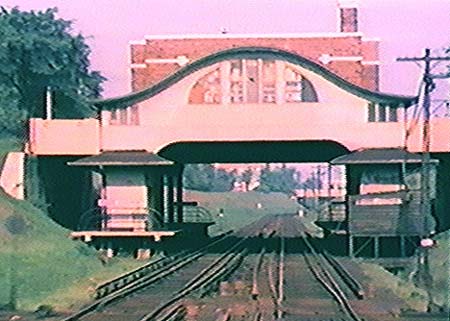
The Ridge station, looking
west, circa 1960. The station house is the brick building on
the bridge in the background. The hump-shaped structure in
front of it is the back of the station, housing the stairs
to the platforms. After closure, the station house was
converted into a commercial building, at one time housing a
candy store. It was abandoned at the time of this
photograph, taken from a moving North Shore Line train. (Photo from North Shore
Line, from Sunday River Productions)
|

Thanks to J.J. Sedelmaier for the information on the stations
post-1948 status.
Notes:
1. "About the Project," Yellow Line Station Engineering Feasibility Study. evanstonyellowlinestation.org. Accessed on 22 February 2012.
2.
Bullington, Jonathan. "Study points to Asbury for possible Yellow Line station." TribLocal: Evanston. 25 January 2012.
3. Ibid.


