Published by: Harrington,
Kelker and De Leuw
Publishing date: 1937
Plan
Summary:
By 1937, there had been substantial changes in transit
prospects. The registration of passenger cars had grown at a
rate which could not be ignored. Whereas there were 35,000
passenger motor vehicles registered in Chicago in 1915, the
number had in creased to 335,000 by 1927 and to 501,000 by
1937. By 1962, nearly 900,000 passenger cars were registered
in the city.
Both the depression and the rise of the automobile
influenced a plan and report prepared in 1937 by Harrington,
Kelker and De Leuw. The Chicago
Area Transportation Study's first regional Chicago
transportation plan, published in 1962, described the 1937
plan this way:
In the letter of transmittal that accompanied
their report, the engineers stated that the objective of
their study was "to paint the way to prompt relief from
the unsatisfactory and progressively declining character
of transit service which the city is now enduring; to
stress... the important role which the private automobile
has assumed as a utilitarian transit vehicle" and to
stress the need for "extensive modernization of both
surface and rapid transit facilities -- all to be
operated with out competition as a unified system." The
engineers did propose a unified transit system operation,
but their plan was far different from those of their
predecessors. The effect of much greater ownership of
private automobiles, together with the more pessimistic
outlook engendered by seven years of depression, must
have been major factors in fixing the proposals arising
from this study.
The elevated system proposed actually is smaller than
the one in existence at that time. The report suggested
tearing down part of the Loop elevated structure and
proposed a north-south subway in State Street as a
replacement. The real reduction in elevated railroad
service, however, came from extensive proposals to
convert certain elevated structures to elevated highways.
The Douglas
Park, Lake
Street, and possibly the Logan
Square elevated structures were earmarked for paving,
with conversion of service to express bus. Additional and
extensive proposals were made for more express and
surface bus lines
Why this plan differs from the others will immediately
be apparent from a glance at Figure 34 which was taken
from that report and brought up-to-date. This figure
shows the level of transit activity from 1901 through
1937. It also illustrates the significantly different
traffic outlook of 1937. While the Harrington report was
optimistic, it took a far different view of future
transit travel than did any of its predecessors. It is
clear that the estimates of potential future traffic play
a most significant part in setting the scale of planned
improvements. This figure is history. It may be
questioned whether the execution of earlier plans might
not have had an effect on transit usage.
These values would undoubtedly have been affected by
the level of transit services. Yet it is clear also that
these facilities alone would not have prevented what is
perhaps the most important cause of the structural shift
in travel habits, the purchase and use of
automobiles.
A February 12, 1938, article in the Chicago Daily Tribune described the conversion of the Lake Street "L" into an elevated highway:
Mayor Edward Kelly announces that he is considering a proposal to convert the Lake Street elevated line into a superhighway, using a $10,000,000 loan from the federal government. Kelly says, "Proponents point out that with a federal loan construction on this Lake street job might be started promptly … A toll of 10 cents per passenger car and perhaps 3 cents from each bus fare would probably be sufficient to make a federal loan self-liquidating."
In a November 22, 1937 report city engineers wrote that the Lake Street elevated structure could be converted into a four-lane elevated highway from the Chicago River to a point three-quarters of a mile from the western city limits for $6,750,000. The price included entrance and exit ramps at the western end of the highway and a terminal at Wacker Drive and Washington Street. Engineers also estimate that a six-lane elevated highway could be built on Randolph Street, connecting with Lake Street at Union Park just east of Ashland Avenue, for approximately $3,250,000. A key feature of the plan is that, unlike the Congress Street highway plan, which requires an expenditure of over $17,000,000 for land and acquisition and the razing of buildings, a Lake Street toll road would require no additional land acquisition for its right of way.
While converting an elevated rapid line into an elevated highway might seem impractical or far-fetched, there is at least one example of it actually happening -- the Gowanus Expressway in Brooklyn was partially built on top of the BMT Third Avenue Elevated in 1940-41, after the el line closed on June 1, 1940, as required by the unification of the city's three subway companies.

|
This Chicago-L.org
article is a stub. It will be expanded
in the future as resources allow. |
|

|

|

.
.
.
.
.
<> ALIGN="Left"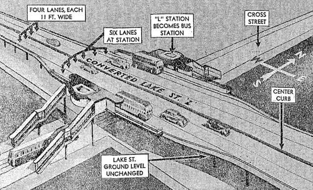
Artist's
rendering of a bus rapid transit station on the elevated highway built from the converted Lake Street "L". Click image for larger view. (Graham
Garfield Collection)
.
|

|


