|
|
|
|
|
|
|
|
|
|
|
|
|
Published by: City of Chicago
Department of Subways and Superhighways Plan Summary: The 1937 comprehensive transit plan formed the basis for subway construction in Chicago, although it only it only proposed one line, the State Street Subway. The State Street Subway proposed in the 1937 plan was a little shorter, extending only as far north as Chicago Avenue. Although the Depression dragged on, the availability of federal public works money from Roosevelt's New Deal programs made construction of subways a real possibility again. The City of Chicago made an application to the Public Works Administration in 1937 for funds for the State Street Subway, as well as a proposed pair of east-west streetcar subways through downtown to relieve surface road traffic. The proposal was favorably received generally, but Secretary of the Interior Harold Ickes -- a native Chicagoan -- disliked the idea of the streetcar subways and required the substitution of a second rapid transit subway, to and from the West Side, instead. Ickes also suggested that the State Street Subway be extended further north. City engineers and Mayor Kelly bristled at the notion that Washington wanted to dictate the city's transit plan, since the city's engineers had thoroughly studied the alignments and concluded that the two streetcar subways would carry a great deal more passengers than a second rapid transit subway would. Ickes was insistent, however, and most importantly held the purse strings. A stalemate ensued for a while, with negotiating and argument back and forth. But in the end, Ickes held most of the power and Kelly decided that a subway with less carrying capacity was better than none at all and eventually acquiesced. Engineering plans for the State Street Subway were quickly prepared, and enough progress had been made on them to allow ground was broken on the State Street tubes in December 1938. Groundbreaking for the Dearborn Subway followed in March 1939. With work on these two subways progressing, the city turned its attention to future expansion and what the city's transit network should ultimately look like. The Comprehensive Plan for the Extension of the Subway System of the City of Chicago was proposed in October 1939, forming the basis for subsequent rapid transit expansion built through 1960. The Comprehensive Plan was vast, incorporating a 50-mile two-track subway system to be built at a cost of $267,000,000. The proposed program included the following projects:
The Comprehensive Plan incorporated the subways already under construction and brought back the two streetcar subways the city had originally wanted. Also included were new crosstown subways and extensions further out into the city. It stressed the fact that the... "outstanding flaw in the existing pattern of Chicago's rapid transit system is the complete absence of facilities for north and south crosstown traffic...", which is still the case today. The plan also included the first appearance of several concepts that would remain in Chicago transit planning for decades afterward. The Comprehensive Plan was the first to suggest the combination of rapid transit and expressway facilities within a common right-of-way. The proposal to remove the Loop Elevated structure would be a core element in several successive transit plans. According to Philip Harrington, commissioner of subways and traction, completion of the program would bring rapid transit service in the form of elevateds, subways or suburban railroads to within one mile of 92 percent of the population of Chicago. The elevated-subway-suburban railroad system would also run within one mile of 78 percent of the city's area. After the U.S. entered World War II two years later, work on any subway lines other than the State Street route (which was declared an essential wartime transportation link for industrial workers) was suspended but the city remained committed to the plan. A brochure issued in 1943 for the opening of he State Street Subway stated that, "the City's plans call for the construction of almost 50 miles of additional subways as extensions of this Initial System in three stages of construction as early as war conditions and financing problems permit." Mayor Edward Kelly said of the plans, "above all, Chicago must have adequate local mass transportation. Insurmountable as it sometimes seems, Chicago will solve this problem. She must do this to deserve her place as the foremost city in the nation."
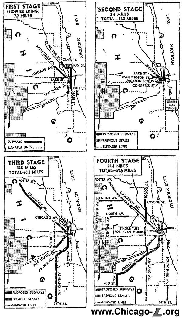
Expansion and Addition Projects: The Comprehensive Plan divided the subway projects into four construction stages: First Stage (under construction at the time of the report):
Second Stage: The Dearborn subway, already under construction, would be extended west along Congress Street to a connection with Garfield Park elevated structure near Halsted street. A subway extension westward was also to be built under Lake street from the Milwaukee-Dearborn Subway to connect to the Lake Street elevated near Racine avenue.
Third Stage: According to the plan, the third stage of the proposed program included subway extensions that would be useful additions to the city's transit system, but which are not so urgently needed as those included in the second stage.
Fourth Stage: The fourth group of subways were projected for future construction, when the traffic demand warrants the investment. They were located in portions of the city where substantial increases in population were expected when the plan was formulated in 1939.
Comprehensive Subway Plan Total [all 4 stages]: 50.50 miles - Estimated cost $267,000,000 Commissioner Harrington said the program would cost approximately $72 per capita to residents of Chicago. This compared with $75 per capita for subways in Philadelphia, and $133 per capita in New York, according to the plan. The cost estimated included station finishes and escalators but excluded cars and other equipment and connections with the elevated structures.
The Results: The Comprehensive Plan for the Extension of the Subway System of the City of Chicago proposed an extensive network of subways throughout the city. Given the cost of subway construction -- a booklet published in 1943 for the opening of the State Street Subway even noted at the time that there would be "financing problems" -- it is not surprising the several of the proposed routes were never built. Financing was the chief reason many of the proposed routes were not built, although changing population and land use patterns following World War II also caused changes in prioritization and suggested alternate markets to serve. Several of the proposed lines were built, however. Some were built as proposed in the plan, while others were realized in terms of general alignment but were modified in terms of specific routing and right-of-way type. Still others, while never built, were carried forward to subsequent transit plans in either precise or general form. The State Street and Milwaukee-Dearborn subways, already under construction when the plan was published, were built as proposed. The State Street Subway opened in October 1943, but the work on the Dearborn Subway was halted due to a materials shortage caused by World War II and it was temporarily mothballed. The Dearborn Subway finally opened in February 1951. Here's how the other proposed projects faired:
. |
|
|
. .
Maps from 1939 showing the four phases of the Comprehensive Plan for the Extension of the Subway System of the City of Chicago. Click image for larger view. (Image reprinted from the Chicago Daily Tribune) .
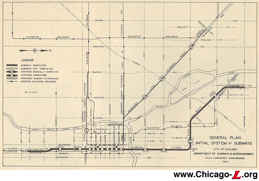
Map of Initial System of Subways and they existed in 1943, with the State Street Subway completed and the Dearborn Subway partially completed. (Image from Chicago Subways, from the Graham Garfield Collection) .
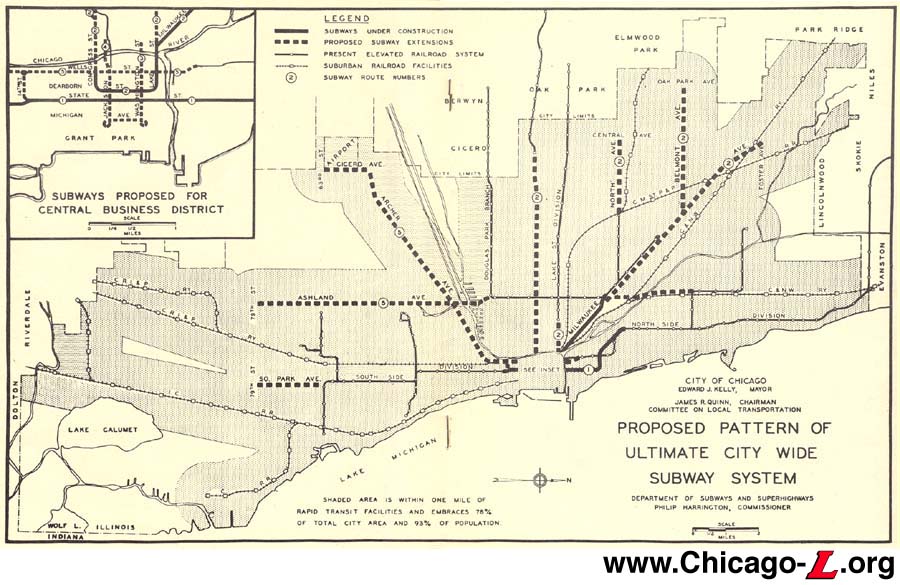
Map showing the proposed pattern of citywide subways, the same system proposed in 1939. (Image from Chicago Subways, from the Graham Garfield Collection) . . |
|
|
|
|